#6. 지구의 끝에서 마주한 외계 행성, 카파도키아 여행 5박 6일 총정리
안녕하세요. 터키 1달 렌터카 일주 시리즈, 어느덧 6번째 이야기로 찾아왔습니다.
오늘은 지중해의 온화한 휴양지 안탈리아를 떠나, 지구가 아닌 다른 행성에 온 듯한 비현실적인 대자연과, 인간의 강인한 생명력이 공존하는 경이로운 세계 카파도키아 여행에서 보낸 스펙터클한 5박 6일간의 여정을 소개해 드리려고 합니다.
겨울 튀르키예 자동차 여행을 준비하시는 분들을 위해 제설 및 도로 상태, 꼭 가보아야 할 필수 명소들, 숨은 로컬 맛집, 그리고 여행 중 마주한 잊지 못할 에피소드기까지 아낌없이 들려 드리겠습니다.
👉Click here to read the English version below!
1. 안탈리아 출발, 이슬람 성지 콘야 경유 여정
1) 겨울 국도 드라이브와 도로 제설 상태
안탈리아를 떠나 동북쪽 내륙으로 진입할수록 창 밖의 풍경은 하얀 설국으로 드라마틱하게 변해갑니다. 사실 겨울철 렌터카 여행이라 빙판길 운전 걱정을 정말 많이 했는데, 다행히 터키 국도의 주요 도로들은 제설작업이 잘 되어 있어 안심하고 달릴 수 있었습니다. 탁 트인 눈 덮인 풍경을 가로지르는 드라이브는 렌터카 여행자만이 느낄 수 있는 일종의 특권이 아닐까 하는 생각이 들었습니다.
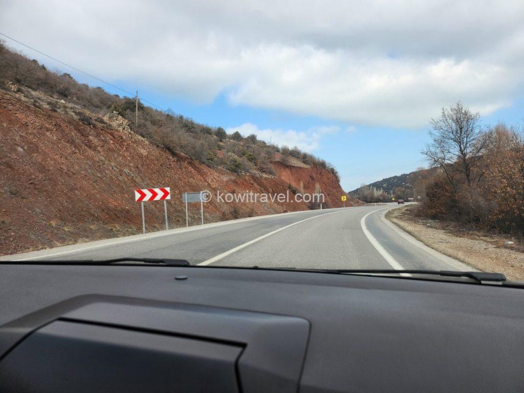
안탈리아를 출발해 콘야로 가는 국도. 왼쪽 산의 단면이 붉은 색을 띠는 이유는, 터키 남부 지중해 연안과 토로스 산맥 일대에 발달해 있는 석회암 지대인데 탄산칼슘 성분의 석회암이 빗물에 녹아 씻겨 내려가고, 녹지 않고 남은 철, 알루미늄 등의 불순물이 쌓여 사진처럼 붉은 진흙을 이룬다고 합니다. 이를 테라 로사(이탈리아어로 ‘붉은 땅’)라고 부른답니다.
안탈리아에서 카파도키아까지의 대장정은 아래와 같습니다.
· 총 이동 거리: 약 500~515km
· 소요 시간: 약 6시간 30분 ~ 7시간 (겨울철 기준)
· 경유지 추천 : 콘야(Konya) – 운전 시작 후 약 3시간 30분 지점
그래서 무리하지 않고 중간 경유지인 콘야(Konya)에서 잠깐 휴식을 취하고 이동하기로 하였습니다.
2) 중간 경유지 콘야(Konya) 메블라나 광장 (Mevlana Square) 휴식
길고 긴 여정의 중간 기착지로 선택한 곳은 터키에서 가장 종교적이고 보수적인 색채를 지닌 도시로 알려진 콘야(Konya)였습니다.
지평선이 끝없이 펼쳐지는 평야 지대로, 터키 최대의 밀 생산지인 콘야는, 11~13세기 번성했던 룸 셀주크 제국의 수도였다고 합니다. 이 시기에 지어진 화려한 중세 이슬람 건축 유산이 도시 곳곳에 남아 있으며, 이스탄불이나 안탈리아 같은 휴양지와 달리 터키에서 가장 보수적이고 경건한 도시로 알려져 있습니다.
또한 콘야는 거장 시인이자 사상가인 메블라나 루미(Rumi)가 활동하고 묻힌 곳이자, 신비주의 수피즘과 ‘춤추는 수도승(세마)’ 발상지로, 전 세계에서 이 평화와 사랑의 메시지를 찾아 매년 수많은 순례자가 방문한다고 합니다.
잠시 차를 주차하고 나서 들른 메블라나 광장은 겨울 추위 속에서 묵직한 엄숙함을 뿜어내고 있었습니다. 웅장한 셀리미예 사원과 이슬람 신비주의인 수피즘의 성지인 메블라나 박물관의 상징인 청록색 타일 돔이 새파란 겨울 하늘과 대비되어 무척 이국적이었습니다.
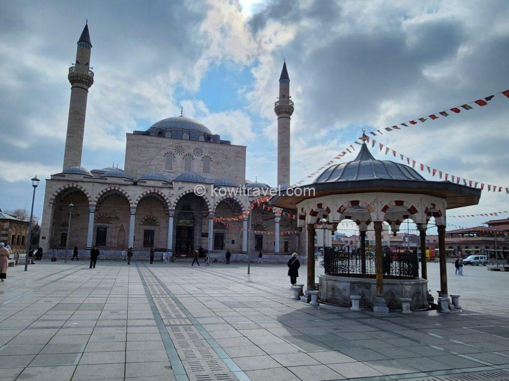
메블라나 박물관 바로 옆에 웅장하게 서 있는 셀리미예 사원(Selimiye Camii)과 광장 중앙의 분수대

수피 댄스(세마댄스)로 잘 알려진 메블라나 루미의 무덤이 있는 메블라나 박물관 외관. 지붕 뒤편으로 보이는 특유의 청록색 타일 돔(Green Dome)이 이 박물관의 상징이랍니다.
잠시 숨을 고르며 터키의 깊은 역사 속으로 걸어 들어간 듯한 멋진 경유지였습니다.
2. 카파도키아 도착
콘야를 출발하여 평탄한 왕복 4차선 국도를 따라 220여km를 쉬임없이 거의 3시간 가량을 달려 네브셰히르(Nevşehir)에 도착할 즈음부터 많은 양의 눈이 내리고 있었습니다. 이전에도 많은 눈이 내렸는지 도로 가장자리로 치워진 눈의 양이 꽤나 수북했습니다.
● 여행 Tip : 콘야 출발 후 약 1시간 40분 정도 달리면 중간 지점에 악사라이(Aksaray)가 위치하고 있으니, 이곳에서 주유를 하거나 가벼운 휴식을 취하고 이동하셔도 좋습니다.
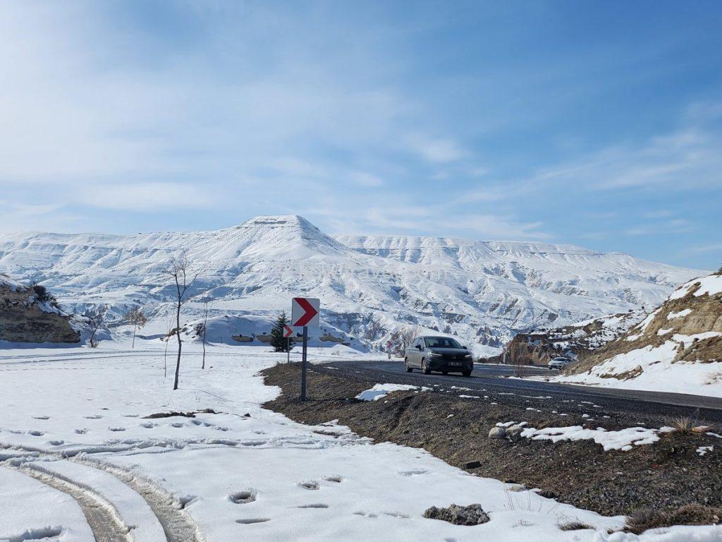
카파도키아 여행 중 온통 하얗게 눈으로 뒤덮인 카파도키아의 광활한 설산을 배경으로 촬영한 도로 모습
그렇게 많은 눈이 내리는 네브셰히르를 거쳐 우치사르 성(Uçhisar Castle)을 지나고, 호텔과 레스토랑, 버스터미널이 밀집한 여행자들의 진짜 중심 타운인 괴레메를 거쳐, 숙소가 있는 차부신(Çavuşin)에 무사히 도착했습니다. 차부신은 복잡한 괴레메 타운에서 북쪽으로 약 4~5km 떨어져 있으며 차로 5분 정도 거리에 있는 아주 가까운 이웃 마을입니다.
👉콘야->네브셰히르->괴레메->차부신까지의 이동 경로 구글맵 보기
머나먼 과거 수 백만년 전 대규모 폭발이 일어나던 화산 지역이었던 카파도키아는, 마그마 분출로 만들어진 용암바위 주위로 폭발 후폭풍인 화산분진이 내려앉아 응회암으로 굳어져 둘러싸였는데, 응회암은 화성암에 비해 경도가 약하기 때문에 쉽게 깎여나가면서 카파도키아 지역 특유의 버섯바위들이 만들어졌다고 합니다.
이 바위들은 도구만 있으면 쉽게 파낼 수 있는 독특한 특성을 가졌기 때문에 중세 로마 제국의 박해와 이슬람 세력의 침공을 피해 수많은 초기 기독교인들이 이곳으로 숨어들어 기독교인들의 피난처가 되었고, 이들이 바위 속을 깊게 파고 들어가 수만 명이 살 수 있는 복잡한 지하 도시를 건설한 것이 바로 데린쿠유와 카이막클리입니다. 또한, 동굴 안에 정교한 프레스코화를 그린 동굴 교회를 만들어 그들의 신앙을 지켜 나갔다고 합니다.
오늘날에는, 그 역사적·자연적 가치를 인정받아 1985년 괴레메 국립공원과 카파도키아 바위 유적지가 유네스코 세계문화유산으로 지정되어 지구상에서 가장 이국적인 풍경을 자랑하는 세계적인 관광 명소가 되었답니다.
또한, 열기구 투어의 성지로 매일 새벽 수백 개의 열기구가 기암괴석 위로 떠오르는 풍경은 카파도키아 여행의 필수 코스이자 전 세계 버킷 리스트 1위로 꼽힙니다.
1) 차부신 마을의 동굴같은 숙소 ‘루트 카파도키아‘ 3박
긴 운전 끝에 드디어 무사히 도착한 우리의 카파도키아 여행 첫 숙소는 차부신 마을에 위치한 ‘루트 카파도키아(Route Cappadocia)’입니다.
괴레메 시내의 북적거림에서 살짝 벗어나 있어 비교적 한적하고 평화로운 분위기를 느낄 수 있고, 고즈넉한 겨울 정취를 즐기기에 안성맞춤인 이 숙소는 아기자기한 정원과 테라스를 갖춘 돌집이자 동굴 콘셉트의 숙소입니다.
거칠고 멋스러운 돌벽으로 둘러싸인 동굴 감성의 베드룸은 영하의 날씨가 무색할 정도로 아늑하고 따뜻했습니다. 마당에 소복이 쌓인 눈의 설경도 로맨틱함 그 자체였죠. 숙소 내에 음식을 주문할 수 있는 메뉴판과 주변 명소에 대한 여행 안내판이 비치되어 있고, 친절한 호스트 덕분에 머무는 내내 내 집에 머무는 듯 편안한 시간을 보낼 수 있었습니다.
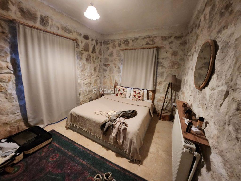
카파도키아 특유의 거칠고 멋스러운 돌벽(Stone wall)으로 둘러싸인 숙소 내부. 은은한 조명과 침대 위 자수 베개가 따뜻한 느낌을 줍니다.

돌로 지어진 숙소 외관과 마당에 쌓인 하얀 눈의 낭만적인 겨울 모습. 고즈넉하고 환상적인 겨울 카파도키아의 정취가 느껴집니다.
Vrbo뿐만 아니라 Booking.com이나 Tripadvisor 등 주요 호텔 예약 사이트에도 등록되어 있어 함께 가격을 비교해 보실 수 있습니다
👉 Tripadvisor에서 Route Cappadocia 예약 실시간 확인하기
2) 1일 차 밤, 요정 마을 같았던 괴레메 시내 야경 산책
숙소에 안전하게 짐을 풀고 나니 어느덧 밤이 되었습니다. 본격적인 카파도키아 여행을 시작하기 위해 저희는 렌터카를 몰아 본격적으로 괴레메(Göreme)의 야경을 감상하고자 설레는 마음으로 시내로 향했습니다.
시내 한 켠에 차를 주차해 놓고, 야경을 즐기고자 괴레메 중심가 안쪽의 언덕진 동굴 호텔 골목길로 조심스레 걸어 올라갔습니다. 순간 마주한 야경은, 너무나도 비현실적이다 못해 신비롭고 몽환적이었습니다.
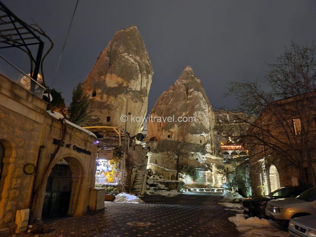
괴레메 중심가 안쪽의 언덕진 동굴 호텔 골목길입니다.
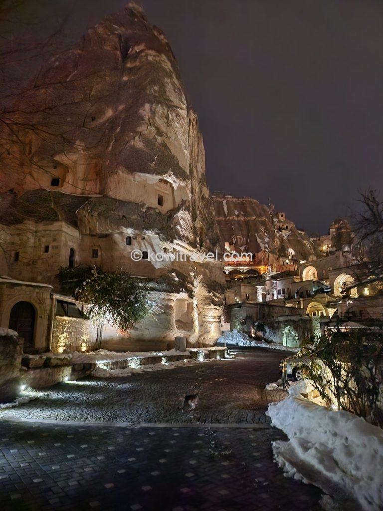
거대한 ‘요정의 굴뚝(Fairy Chimneys)’ 바위 자체를 깎아 만든 동굴 숙소들과 따뜻한 오렌지빛 조명이 눈 위로 반사되어 아주 낭만적입니다.
거대한 ‘요정의 굴뚝(Fairy Chimneys)’ 바위 자체를 깎아 만든 동굴 숙소들과 따뜻한 오렌지빛 조명을 받은 기암괴석, 하얀 눈 위로 반사되는 조명이 아주 낭만적이어서, 그 사이를 걷는 것만으로도 마치 다른 행성에 와 있는 듯한 기분이었습니다.
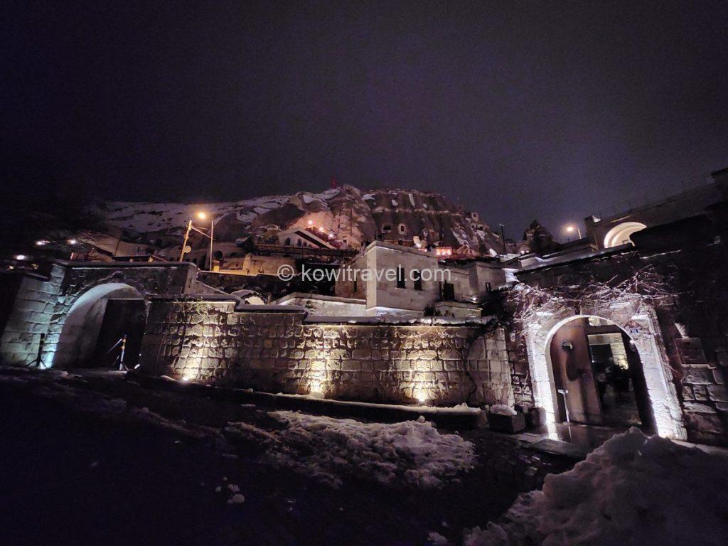
바위산을 그대로 활용해 성벽과 테라스를 쌓아 올린 전형적인 카파도키아 고급 동굴 호텔의 외관
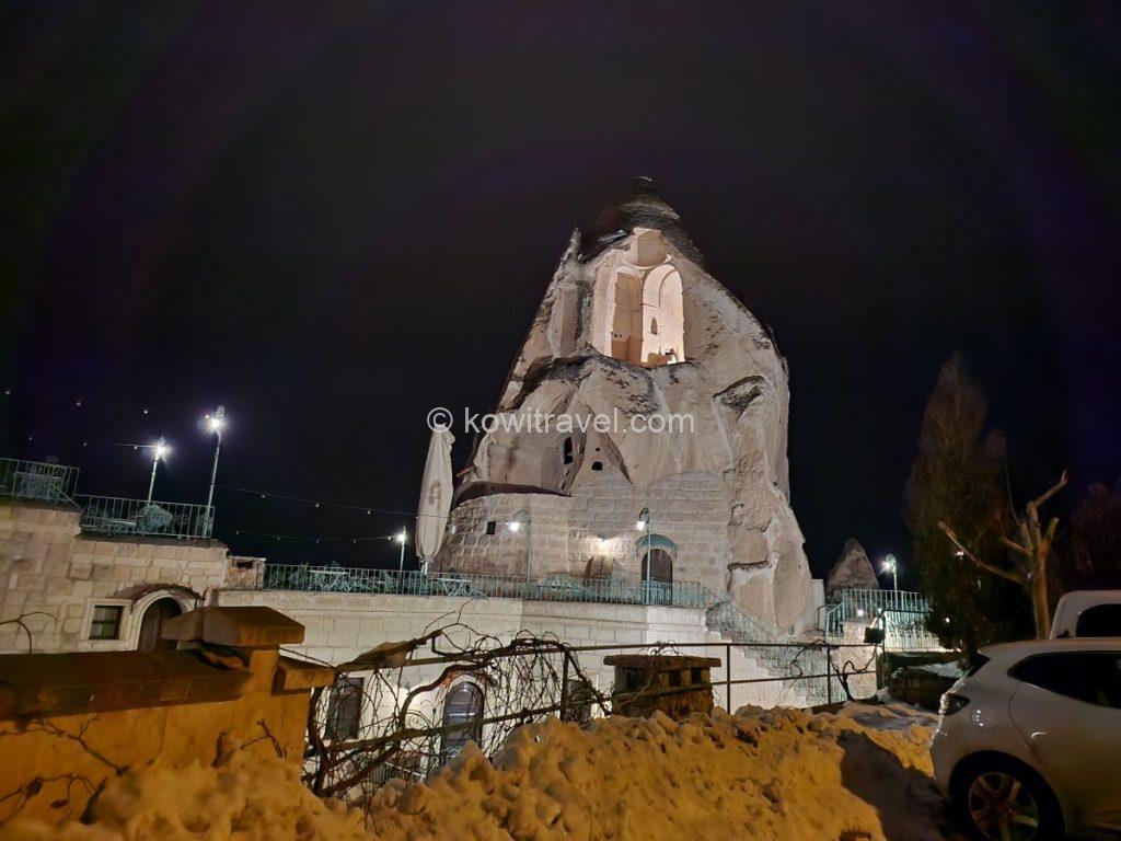
하나의 거대한 첨탑 바위 전체를 조명으로 쏘아 올려 밤하늘 속에서 웅장하게 빛나는 모습이 인상적입니다.
어두운 밤인데다 쌓인 눈으로 인해 경사진 길 자체도 미끄러워 선셋 포인트까지 올라갈 수는 없었지만, 이 동굴숙소 골목길에서 내려다본 괴레메 시내의 야경은 겨울 카파도키아 여행의 낭만을 첫날부터 정점으로 끌어올려 주었습니다.
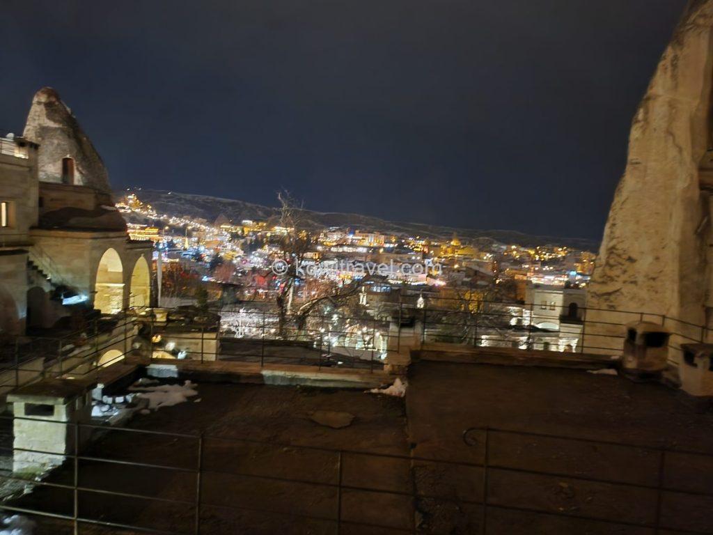
높은 지대의 테라스나 괴레메 선셋 포인트(Sunset Point)로 올라가는 언덕길에서 내려다본 시내 전경입니다.

멀리 눈 덮인 거대한 바위산 아래로 아기자기하게 불을 밝힌 괴레메 마을 전경 . 도로 위 매끄럽게 얼어붙은 눈길이 겨울 터키 여행의 생생함을 더해줍니다.
3. 카파도키아 여행 핵심 필수 명소 코스
카파도키아 여행에 5박 6일이라는 긴 시간을 할애한 이유는, 워낙 명소가 많기도 했지만, 카파도키아의 꽃인 ‘벌룬(열기구) 투어’를 하기 위해서였습니다. 매일 아침 실시간으로 벌룬 가능 여부를 알려주는 앱을 켜두고 간절히 기다리며 카파도키아 곳곳을 여행했습니다.
1) 거대 지하도시 데린쿠유 지하도시 탐험과 아찔했던 차 키 분실 에피소드
카파도키아 여행에서의 둘째 날, 저희가 향한 곳은 거대 지하도시인 데린쿠유(Derinkuyu)였습니다.
차부신(Çavuşin)에서 데린쿠유 지하도시 까지는 자동차로 약 38~39km, 소요 시간은 약 40~45분 정도 걸리며, 괴레메와 우치사르 주변을 지나 남쪽으로 쭉 내려가는 코스입니다. 국도를 타게 되는데, 도로 폭이 넓고 한적한 편이라 운전하기에 까다롭지는 않습니다.
데린쿠유 지하도시를 다 둘러보는 데는 보통 1시간 정도 소요됩니다.
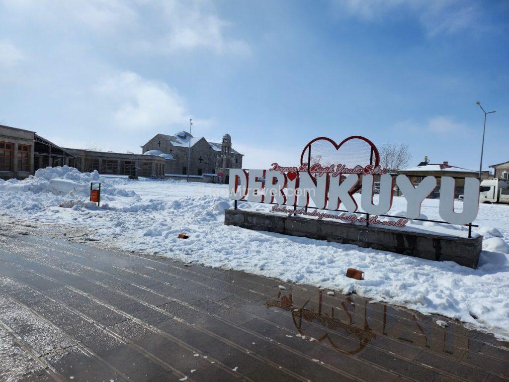
데린쿠유 지하도시 광장에 설치된 공식 시그니처 조형물
카파도키아 지역에서 발견된 지하도시 중 최대 규모이자 가장 깊은 곳으로, 터키어로 ‘깊은 우물’을 뜻하는 데린쿠유 지하도시(Derinkuyu Underground City)는 기원전 시대부터 조금씩 파이기 시작했으나, 7~8세기경 비잔틴 시대에 이슬람 세력과 로마 제국의 종교 탄압을 피해 숨어든 기독교인들에 의해 그들의 종교적 피난처로 대규모로 확장되었다고 합니다.
전체 깊이 약 85m(지하 18~20층 규모)에 달한다고 하는 이 지하도시는, 단순한 동굴이 아니라 지하 내부에 주거지, 주방, 식량 창고는 물론 교회, 신학교, 와이너리, 마구간까지 완벽하게 갖추어진 도시 기능이 완비되어 장기간 지상으로 나가지 않고도 자급자족이 가능했다고 합니다,


데린쿠유 지하도시의 공식 티켓 오피스 매표소와 지하도시로 들어가는 좁고 가파른 입구
전성기에는 약 2만 명의 주민과 그들의 가축, 식량까지 동시에 수용할 수 있었던 거대 거주 공간이었다고 하니, 지금처럼 전문 장비조차 없던 고대 기술로 만들었다고 믿기 힘들 만큼의 정교함이 경이로웠습니다.
현재 일반인에게는 안전상 지하 8층(약 30~40m 깊이)까지만 개방되어 있습니다.


과거 기독교인들이 박해를 피해 숨어 살았던 거대한 지하 생활 공간들
허리를 숙이고 좁은 돌계단을 따라 내려가면 적의 침입을 막기 위해 안에서만 굴릴 수 있는 거대한 맷돌 모양의 돌문과 거대한 돌기둥들이 나타납니다. 박해를 피해 이 어둡고 좁은 지하 세계에서 공동체를 이루고 신앙을 지켰을 고대인들의 처절하고 힘겨웠던 삶과 그들의 지혜에 숙연해지는 순간이었습니다.
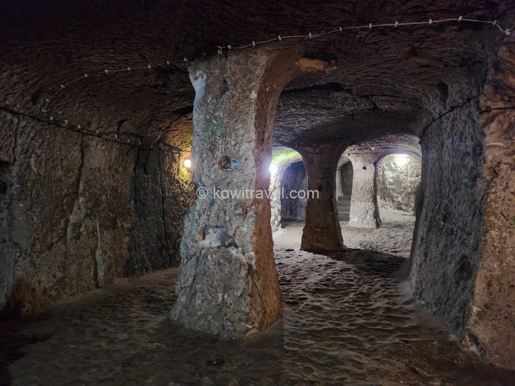
지하 도시를 지탱하는 두꺼운 바위 기둥들과 여러 갈래로 나뉘는 복잡한 미로 형태의 통로
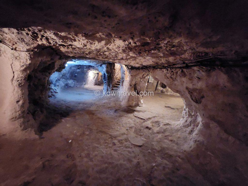
조금 더 넓은 생활 공간이나 광장 형태의 구역. 천장이 낮고 둥글게 깎여 있으며, 뒤쪽으로는 위아래 층을 연결하는 비좁은 계단 통로가 보입니다.


데린쿠유 지하도시의 가장 핵심적인 볼거리인 “돌문”. 외부 적의 침입을 막기 위해 안에서만 굴려 잠글 수 있도록 만든 맷돌 모양의 거대한 돌문이며, 중앙의 구멍은 적을 감시하거나 창을 찌를 수 있게 하기 위함이라고 합니다.
지하도시 매표소 바로 앞 광장 한쪽에 위치한 아기오스 테오도로스 안나르기리 교회(Agios Theodoros Trion Church)가 있습니다. 19세기 이 지역에 살던 그리스계 정착민(그리스 정교회 신자)들을 위해 세워진 유서 깊은 석조 건물인 그리스 정교회 성당이랍니다
훌륭한 음향 효과와 가브리엘·미카엘 천사 등의 아름다운 프레스코화 잔해가 남아있다는데, 1923년 그리스와 터키 간의 주민 대교환 이후 교회가 비어 방치되기 시작한 이후 오랜 세월동안 관리 소홀과 일부 낙서로 인해 훼손되어 현재는 문이 잠겨 있어 내부는 볼 수 없고 외관 위주로 가볍게 둘러보는 코스로 이용되고 있답니다.
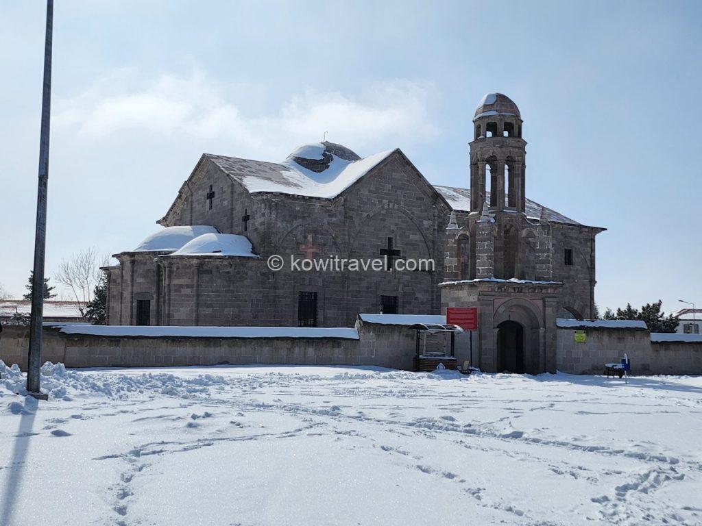
19세기에 지어진 역사적인 그리스 정교회 성당입니다. 카파도키아 특유의 돌로 견고하게 지어졌으며, 눈이 소복이 쌓인 웅장한 종탑이 겨울 하늘과 어우러져 고즈넉한 미를 보여줍니다.
미로처럼 복잡한 지하도시 구석구석 탐방을 마치고 나오니 배도 고프고 때마침 점심 시간이라 저희는 주차장 근처의 로컬 식당 ‘Akdeniz Kebap Salonu’로 향했습니다. 눈 내린 모스크의 첨탑이 정면으로 보이는 소박한 로컬 식당이었는데, 여기서 맛본 숯불 향 가득한 아다나 케밥과 새콤한 메제(밑반찬), 그리고 아이란의 조합은 독특하면서도 괜찮았습니다.

데린쿠유 지하도시 매표소 및 주차장 바로 근처에 위치한 현지 로컬 식당
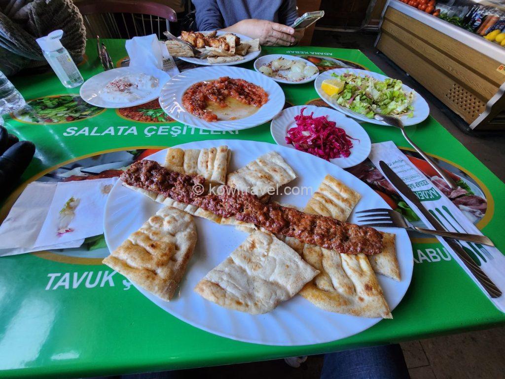
터키의 대표적인 고기 구이인 아다나 케밥(Adana Kebabı). 다진 양념 고기를 꼬치에 끼워 숯불에 구운 뒤, 터키식 빵 피데(Pide) 위에 올려 함께 싸 먹는 요리입니다.


식당 내부 모습과, 인근의 대표 사원. 거대한 돔과 두 개의 높고 뾰족한 첨탑(미나레)이 겨울의 새파란 카파도키아 하늘과 대비되어 매우 이국적입니다.
- 에피소드 : 아찔했던 순간 마주한 튀르키예인들의 잊지 못할 친절
하지만, 식사를 마치고 나오면서 지금도 잊지 못할 아찔하면서도 황당했던 카파도키아 여행의 최고 위기 상황이 저희를 기다리고 있을 줄은 꿈에도 몰랐습니다.
분명 아내가 자켓 주머니에 잘 넣어두었다고 생각했던 렌터카 키가 감쪽같이 사라진 사실을 주차장에서 와서야 알게 되었을 때
‘설마 이게 현실일까’ 싶을 정도로 막막했습니다.
우리 차가 나가는 줄 알고 다가오는 주차요원에게 차 키가 분실된 상황을 설명하고 있는 와중에 주차요원 동네친구쯤 되어 보이는 아저씨가 영어 반 터키어 반, 때로는 번역기 돌려가며 “잘 생각해 봐. 차 세우고 제일 먼저 어디 갔는데? 화장실이라고? 어느 화장실? 모스크 화장실이라고?” 하면서 무슬림 아저씨가 이슬람 문화권에서 남녀 구분이 엄격함에도 불구하고 제 아내와 함께 여자 화장실 들어가 샅샅이 찾아봐 주셨습니다.
그 사이에 저는 식당까지 오갔던 길을 다시 꼼꼼히 살펴보고 왔지만 허사였고, 어쩔 수 없이 마지막 안 찾아본 곳, 지하도시로 다시 들어가 보기로 하고 매표소에 상황을 설명한 후 지하도시에 다시 들어갔습니다. 그 좁고 길고 수없이 많은 갈래길이 있는 지하도시를 핸드폰 손전등 켜고 한겨울에 땀 뻘뻘 흘리며 찾아봐도 못 찾은 채 결국 빈손으로 지상으로 올라왔을 때 이 상황이 앞으로 어찌될지 생각하니 보통 큰 일이 아니었습니다.
당장 날은 조금 있으면 어두워지고 겨울 추위는 매서운데, 이스탄불에서 카파도키아까지 열쇠가 금방 올 수 있는 거리도 아니고, 그렇다면 결국 차를 견인해 가야 할 것이고, 우리는 견인차가 올 때까지 이 추위에 달달 떨며 기다려야 하고, 숙소는 어떻게 돌아갈 것이며 아무리 풀 커버(Full Cover)라고 해도 열쇠분실과 그에 따른 견인비용은 커버가 안될 것 등등을 생각하니 그야말로 하늘이 깜깜해지는 상황이었습니다.
그렇게 망연자실하고 있는데, 그 번역기 무슬림 아저씨가 득달같이 달려와 “차 키 찾았어?” 하고 묻는데 이미 머릿속이 하얘진 상태라 대답할 정신도 없었습니다. 그런데 이 아저씨가 주변 상점 사람들에게 자기들 언어로 무어라 말을 하더군요. 그 때, 길 건너 기념품가게 아저씨가 무어라 말하면서 손을 흔들어 대는데 그 손가락에 우리의 차 열쇠가 있는 게 아니겠어요! ‘눈 위에 떨어져 있었다고, 그래서 자기가 주워서 보관하고 있었다고’ 하면서..
막상 우리는 맥이 풀려 기뻐하지도 못하는데 우리보다 더 기뻐하던 그 거리의 아저씨들의 모습이 지금도 눈에 선합니다.
너무나 고마우면서도 기진맥진한 상태라 아직도 믿기지 않는 꿈만 같았습니다. 현금이든 다른 방식이든 꼭 보답을 해드리고 싶은 저희 마음을 전해드렸으나, 그 아저씨는 “그냥 할 일을 했을 뿐”이라며 연신 손사래를 치며 사양하셨습니다. 결국 그 따뜻한 마음에 보답하고자 아저씨의 노점상에서 귀여운 기념품들을 몇 가지 구매하는 것으로 감사의 마음을 대신했습니다.
지금 생각해도 가슴이 찌릿해질 정도로 고마운, 튀르키예 사람들의 착하고 순수한 정과 그들의 친절을 온몸으로 느낀 꿈만 같은 순간이었습니다.
2) ‘세 자매 바위‘ , 파노라마 전망대
놀란 가슴을 쓸어내리고 숙소로 돌아오는 국도변, 우르굽 마을로 들어가는 입구 언덕에 위치한 전망대를 발견했습니다.
도로 바로 옆에 전망대와 주차장이 잘 마련되어 있어 접근성이 좋은 편이라, 차를 세우고 내리니 마침 오후 4시를 넘기며 겨울날의 석양이 시작되고 있었습니다. 알고 보니 이곳이 카파도키아의 시그니처인 ‘세 자매 바위(Üç Güzeller)’가 있는 파노라마 전망대였습니다.
- 세 자매 바위 (Üç Güzeller / Three Beauties)
터키어로는 ‘위치 귀젤레르(Üç Güzeller)’, 영어로는 ‘세 미녀’ 또는 한국 여행객들에게 ‘세 자매 바위(또는 가족 바위)’라고 불리는데, 지리적으로 괴레메 타운에서 동쪽 방향인우르굽(Ürgüp) 마을로 들어가는 도로변 입구 언덕에 위치해 있습니다.
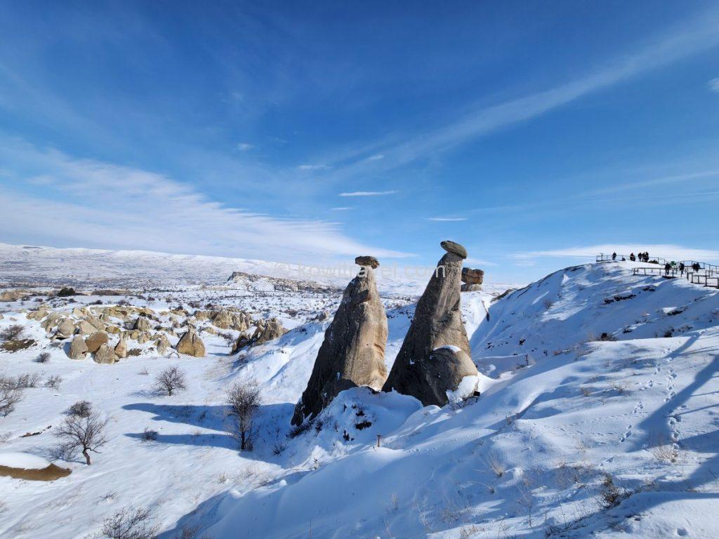
우르굽의 가장 유명한 상징인 버섯 모양 바위 3개가 나란히 서 있는 세 자매 바위(Üç Güzeller)와 그 주변으로 끝없이 이어지는 신비로운 화산 응회암 군락의 겨울 풍경
괴레메 중심가에서는 차로 약 10~12분(약 6.5km) 정도 걸립니다. 도로 바로 옆에 전망대와 주차장이 잘 마련되어 있어 접근성이 매우 좋으며, 이동동선을 계획하실 때 데린쿠유 방문 후 괴레메쪽으로 돌아오는 길에 배치하시면 시간 절약에 매우 효율적입니다.
지질학적으로 하단의 부드러운 흰색 응회암 화산재층은 바람과 비에 쉽게 깎여 나간 반면, 상단의 어둡고 단단한 현무암층은 침식을 견디고 그대로 남아 마치 ‘모자를 쓴 버섯’이나 ‘망토를 두른 사람’ 같은 독특한 형태를 유지하고 있다고 하며, 오랜 세월 차별 침식을 거치며 기둥 모양으로 남은 세 개의 바위가 나란히 서 있는 모습이 독특하고 아름다워 카파도키아 여행기념품이나 엽서에 가장 많이 등장합니다.
이 바위에는 현지에서 내려오는 유명한 세 가지 전설이 얽혀 있다고 전해진답니다.
- 옛날 우르굽의 왕이 목동과 사랑에 빠져 도망쳐 아이까지 낳은 공주를 용서하지 못해 군대를 보냈고, 군대에게 잡히기 직전 공주가 “차라리 돌이 되게 해달라”고 기도하자 하늘이 응답해 공주(가운데), 남편(왼쪽), 그리고 아이(오른쪽)가 그대로 돌 바위로 변했다는 비극적인 공주이야기가 있고,
- 인간 세상의 목동을 사랑한 요정 공주들이 왕의 노여움을 사 도망치다 바위로 굳어버렸다는 인간과 요정의 사랑에 관한 설화가 있으며,
- 서양권에서는 그리스 신화 속 아름다움과 우아함을 상징하는 ‘카리테스(세 그레이스 여신)’의 형상으로 비유하기도 합니다.
소복하게 흰 눈을 뒤집어쓴 버섯 바위들과 거대한 협곡이 지는 해를 받아 붉고 황금빛으로 타오르는 장관은 정말 압권이었습니다.


전망대 데크와 주차장 쪽에서 바라본, 우르굽과 괴레메 경계의 거대한 골짜기전경
멀리 지평선 너머로 구름을 뚫고 솟아오른 에르지예스 화산의 거대한 실루엣까지 선명하게 조망할 수 있었는데, 렌터카 여행이 아니었다면 그냥 지나쳤을 이 여유가 너무나 감사한 순간이었습니다.

오후 4시가 넘어가며 낮게 깔린 겨울 햇살이 눈 덮인 절벽에 부딪혀 붉은빛과 황금빛이 감도는 웅장한 파노라마를 만들어냅니다.
3) 유네스코 세계문화유산 괴레메 야외 박물관과 어둠의 교회
카파도키아 여행 셋째날에 찾은 유네스코 세계문화유산 괴레메 야외 박물관은, 척박한 바위산을 깎아 층층이 방을 만들고 신앙을 지켰던 고대 기독교인들의 터전입니다.


괴레메 야외 박물관 표지판과 매표소의 공식 요금표
4세기부터 11세기까지 로마와 이슬람의 박해를 피해 숨어든 기독교인들이 바위산을 파서 만든 수십 개의 수도원과 교회들이 모여 있는 곳입니다.
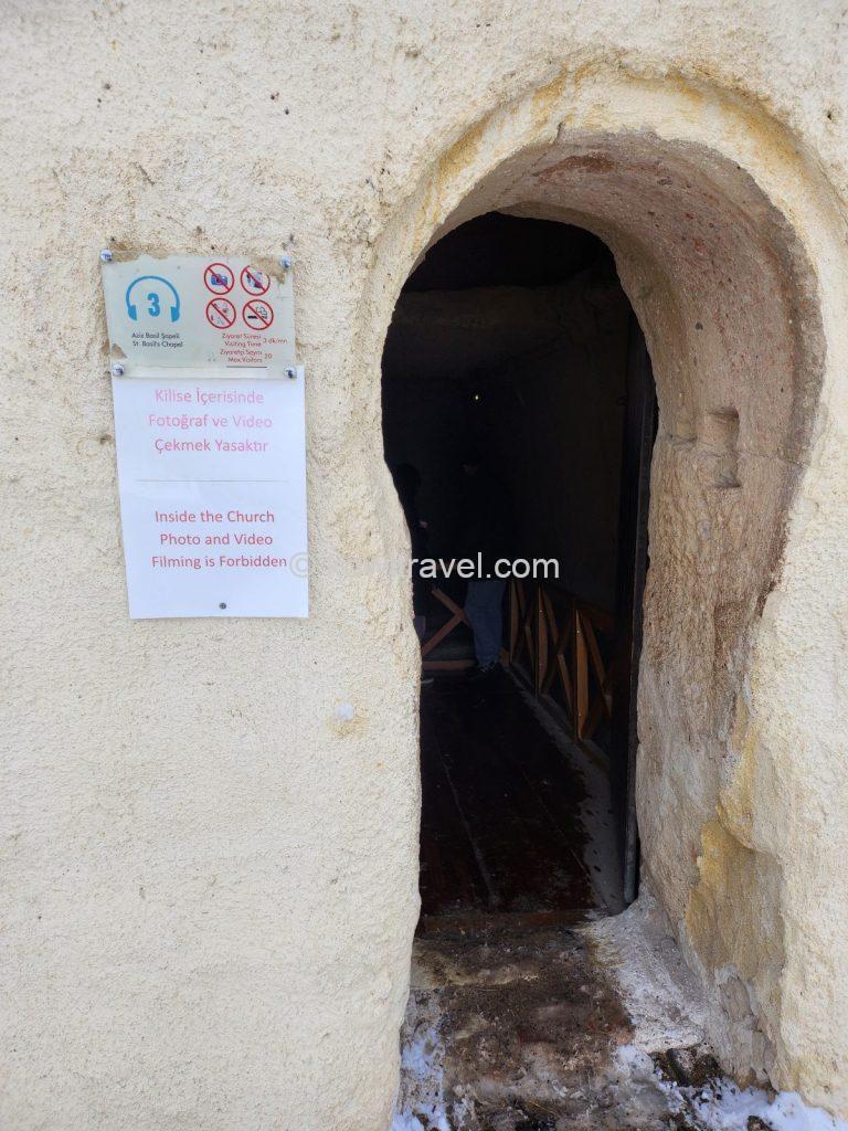
박물관 초입에 위치한 ‘성 바실리오 예배당(St. Basil’s Chapel)’의 아치형 입구


박물관 내부의 대표적인 볼거리인 동굴 교회 바위산. 6~7층 높이의 거대한 바위 내부를 깎아 식당, 주방, 침실, 교회 등을 완벽하게 구축해 둔 카파도키아 정착민들의 생활 터전이랍니다.
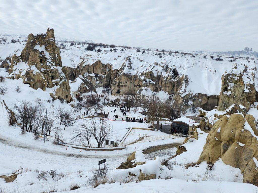
야외 박물관 초입 언덕에서 내려다본 전체적인 풍경.눈 덮인 겨울의 골짜기는 마치 시간이 멈춘 듯 고요하고 신비로운 분위기를 자아냅니다.
바위 동굴 내부로 들어가면 보존 상태가 뛰어난 성화(프레스코화)를 볼 수 있고, 특히 ‘어둠의 교회(Dark Church)’ 내부의 ‘최후의 만찬’ 프레스코화는 수백 년의 세월이 믿기지 않을 만큼 선명하고 정교해 온몸에 전율이 돋았습니다.

카파도키아 전체에서 벽화 보존 상태가 가장 뛰어난 어둠의 교회(Dark Church) 내부의 모습. 사진 속 아치형 벽면에는 기독교 역사에서 가장 유명한 장면 중 하나인 ‘최후의 만찬’ 프레스코화가 선명하게 남아 있습니다.


과거 수도사들이 모여 식사를 하던 식당공간이랍니다. 바위를 길게 깎아내어 일체형으로 만든 돌 식탁과 긴 의자가 인상적입니다. 식탁 끝 안쪽 벽면에는 예수의 생애나 성경 속 장면을 묘사한 세월의 흔적이 묻어나는 프레스코화가 보존되어 있습니다.
4) 파샤바 계곡의 요정의 굴뚝과 독특한 액자 뷰
이어서 방문한 파샤바 계곡(Pasabag Valley)은, 흔히 ‘요정의 굴뚝’이라 부르는 카파도키아 특유의 기암괴석 중에서도 가장 기이하고 아름다운 버섯 모양 바위들이 밀집해 있는 버섯바위 군락지입니다.
과거 화산 폭발로 쌓인 부드러운 응회암 위를 단단한 현무암 층이 덮은 후, 오랜 세월 동안 바람과 비에 차별 침식되면서 지금의 윗부분만 모자처럼 남겨졌다는 자연의 걸작입니다.
과거 수도사들이 이 높은 바위 위에서 고독하게 수행을 했다고 하여 ‘수도사의 계곡’으로도 불린다고 합니다.
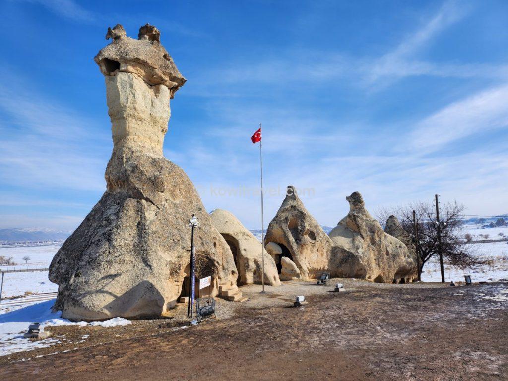
하나의 거대한 바위 기둥 위로 머리가 두 개, 세 개씩 갈라져 있는 파샤바의 가장 대표적인 기암괴석들. 포토존입니다.
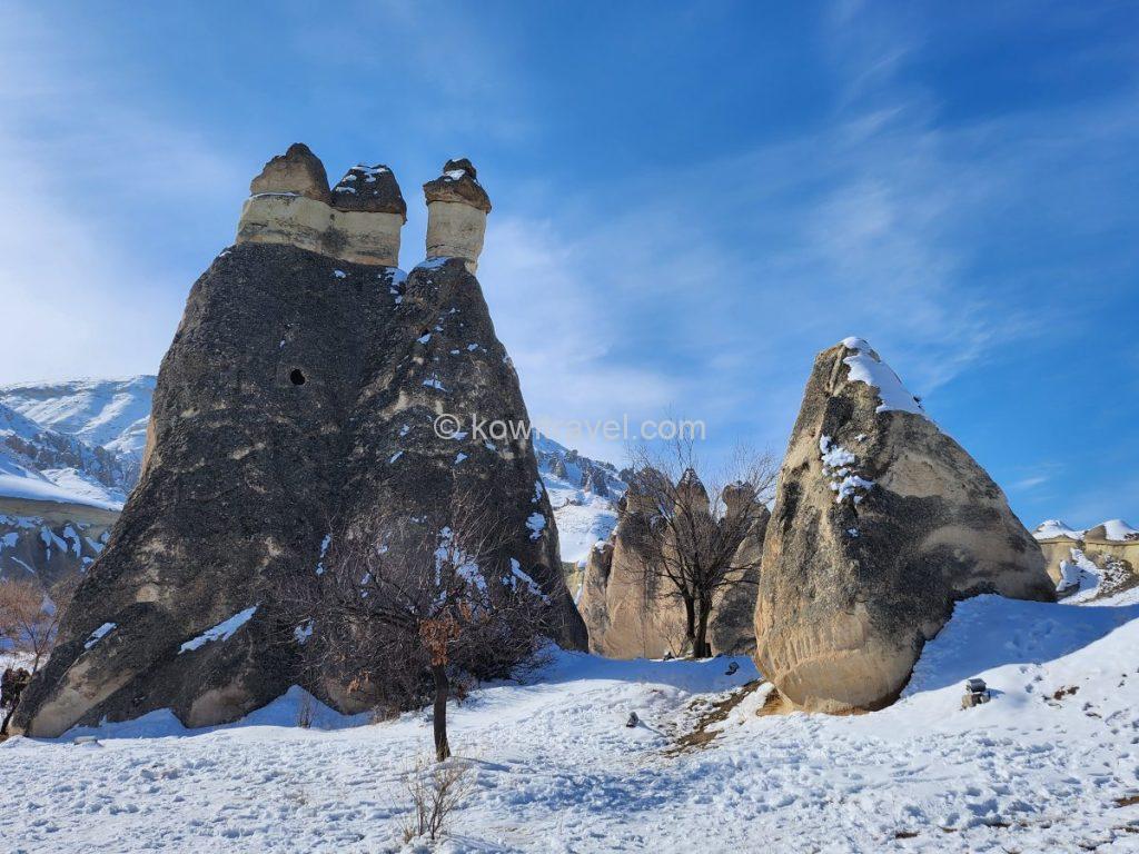
머리에 모자를 쓴 듯한 수많은 버섯 바위(요정의 굴뚝)들이 군락을 이루고 있어 요정 마을에 온 듯한 착각을 불러일으킵니다.


파샤바 계곡 전경과 눈 덮인 광장. 하얗게 쌓인 눈과 푸른 겨울 하늘이 어우러져 마치 동화 속 한 장면처럼 느껴집니다.

버섯바위 밑에서 촬영한 꼭대기의 ‘모자(갓)’ 바위 클로즈업. 오랜 세월 동안 풍화되어 거칠어진 응회암의 텍스처와, 두 겹으로 얹어진 단단한 현무암 층의 경계가 아주 생생하게 보입니다.
특히 동굴 방 내부 창문 구멍을 프레임 삼아 바깥의 버섯 바위를 담는 ‘액자 뷰‘는 인생 사진을 건질 수 있는 최고의 포토존입니다.
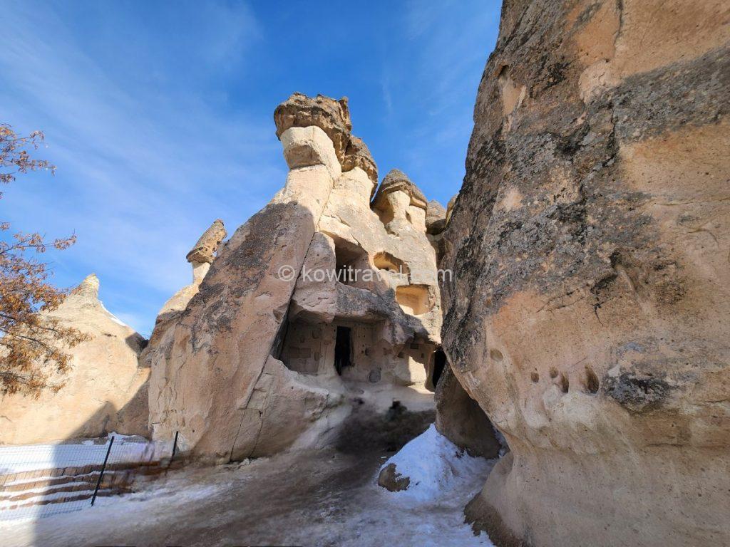
거대한 버섯 모양 바위 하부에 사람들이 직접 손으로 파서 만든 동굴 주거지(또는 수도실)의 입구와 창문들. 고대 기독교 수도사들이 외부 세계와 단절된 채 수행을 하던 공간입니다.
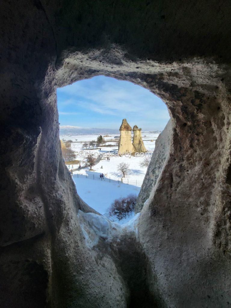
동굴 주거지 내부의 창을 통해 밖을 내다보며 촬용한 사진. 타원형의 바위 구멍이 마치 자연 액자 같은 역할을 하며, 눈 덮인 하얀 평원 위에 외롭게 솟아 있는 또 다른 버섯 바위들이 한 폭의 그림을 연상케 합니다.
5세기경 성 시메온 성인(St. Simeon)이 은둔하며 평생 수행했던 거대한 바위 구멍의 흔적도 직접 눈으로 확인할 수 있었습니다.
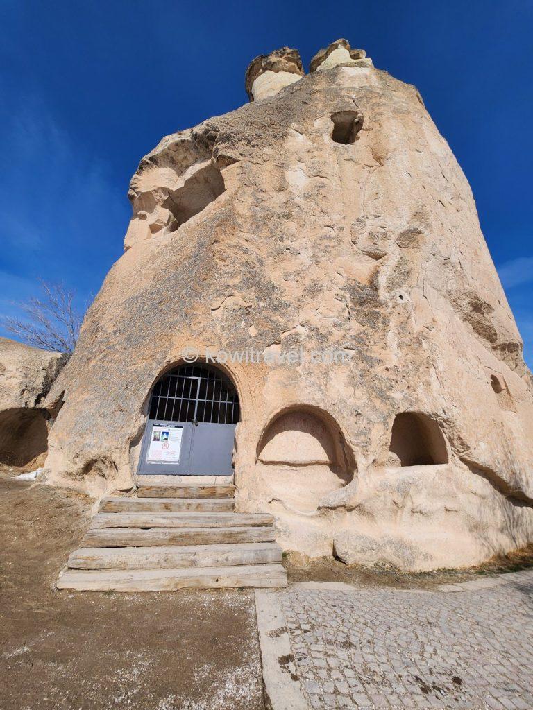
파샤바 계곡에서 가장 역사적으로 중요한 ‘성 시메온 예배당/수도원(St. Simeon’s Hermitage)’ 바위입니다. 철문으로 닫힌 입구와 계단의 모습.
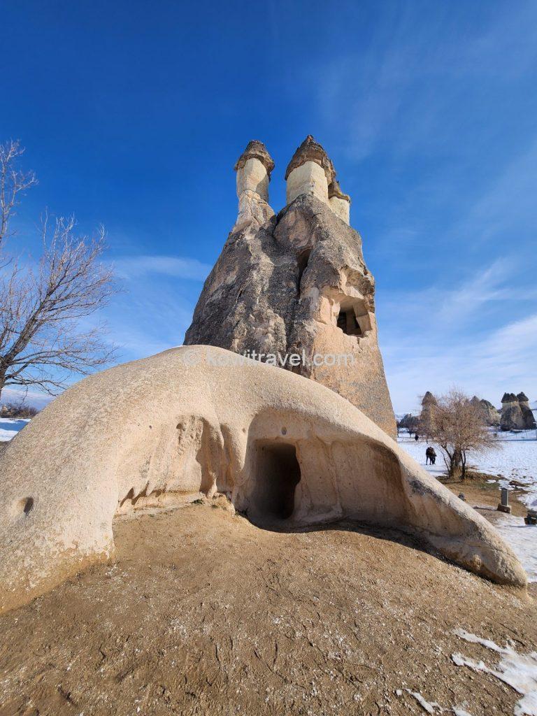
동굴 안쪽 구멍들은 과거 기독교 수도사들이 사다리를 타고 위아래로 이동하며 외부와 단절된 채 기도를 드렸던 수도원 내부 입구의 모습입니다.
5) 날것의 매력을 지닌 젤베 야외 박물관((Zelve Open Air Museum)
파샤바 계곡 바로 옆에는, 기독교인들의 종교적 대피소였을 뿐만 아니라 1950년대까지 실제로 사람들이 거주했던 대규모 동굴 마을인 ‘젤베 야외 박물관’이 자리하고 있습니다.
이곳은 9세기에서 13세기 사이, 기독교인들이 로마와 이슬람교도의 박해를 피해 숨어들며 수도원 공동체로 번성했던 곳으로, 괴레메 야외 박물관과 달리 1952년까지 실제로 이슬람교도와 기독교인 주민들이 마을을 이루어 살던 곳입니다. 바위가 무너지는 위험 때문에 정부에서 주민들을 강제 이주시킨 후 지금의 야외 박물관이 되었다고 합니다.
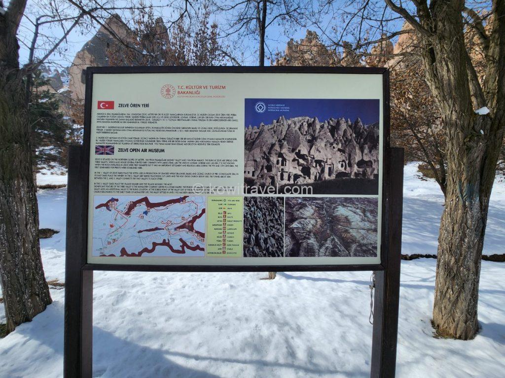
젤베 야외 박물관 입구에 세워진 공식 안내판. 젤베 계곡의 역사와 구조, 탐방로 지도가 튀르키예어와 영어로 상세히 기록되어 있습니다.
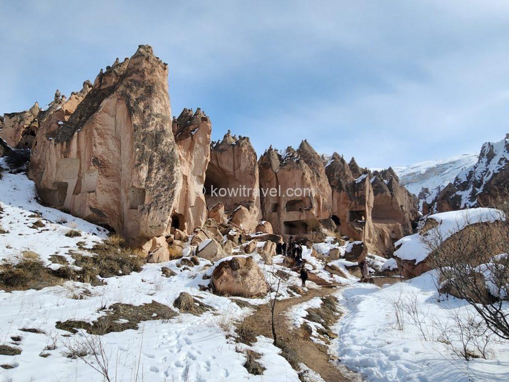
젤베 계곡의 전체적인 암벽 주거지 전경과 탐방로. 세 개의 거대한 골짜기로 이루어진 젤베의 깎아지른 듯한 암벽 절벽 곳곳에 집, 교회, 창고 등으로 쓰였던 구멍들이 촘촘하게 뚫려 있습니다.


멀리서 바라본 암벽 주거지와 계곡 위쪽에서 내려다본 젤베 마을 전체의 입체적인 구조
규모로는 괴레메보다 훨씬 거대하고 날것의 매력을 지닌 이곳은 1950년대까지 실제 주민들이 거주했던 거대한 동굴 아파트 군락 같은 골짜기로, 세 개의 거대한 계곡을 따라 교회, 주거지, 제분소, 비둘기 집 등이 바위산 전체에 거미줄처럼 얽혀 있어, 괴레메보다 훨씬 더 가공되지 않은 황량하고 웅장한 대자연의 스케일을 느낄 수 있습니다.
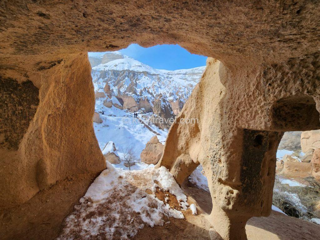
동굴 안쪽에서 바라본 젤베 계곡의 모습


거대한 바위 절벽 아래 뚫린 동굴 주거지의 입구와 동굴 내부의 아치형 통로
6) 우치사르 성(Uçhisar Kalesi)
‘우치사르’는 터키어로 ‘세 번째 성채’ 또는 ‘가장자리 성’이라는 뜻이라고 하는데, 이름에 걸맞게 카파도키아에서 가장 높은 해발 약 1,300m 지대에 우뚝 솟아 있는 거대한 천연 바위 산 성채입니다.
과거 로마·비잔틴 제국 시절부터 셀주크 투르크 시기에 이르기까지 군사적 요새로 사용되었다고 하는데, 겉에서 보면 하나의 거대한 바위산 같지만, 내부를 벌집처럼 촘촘하게 파내어 수많은 방, 통로, 창고, 심지어 주거 공간과 대피소까지 만들어 둔 고대 지하 도시의 지상 버전입니다. 외적의 침입이 있을 때 바위 안으로 숨어들어 문을 잠그고 방어했다고 합니다.
카파도키아 전체에서 가장 지대가 높기 때문에, 성채 정상에 올라가면 괴레메의 계곡, 피죤 밸리, 마을까지 360도 파노라마 뷰가 막힘없이 펼쳐지며, 특히 일출 때 수많은 열기구가 떠오르는 장관이나 붉게 물드는 일몰을 보기 위해 전 세계 여행객이 모여든다고 합니다.

석양이 질 무렵 은은한 황금빛 조명을 받은 듯한 우치사르 성

성채 아랫부분의 동굴 주거지들 모습
7) 선셋포인트 (Sunset Point)
카파도키아의 선셋 포인트(Sunset Point)는 보통 레드 밸리(Red Valley)와 로즈 밸리(Rose Valley)가 만나는 능선에 위치한 전망대로, 해가 질 때 하얀 응회암 암석들이 햇빛의 각도에 따라 분홍빛에서 붉은빛으로 타오르듯 변하는 ‘붉은 노을의 장관’을 볼 수 있어, 카파도키아에서 가장 유명한 일몰 명소입니다.
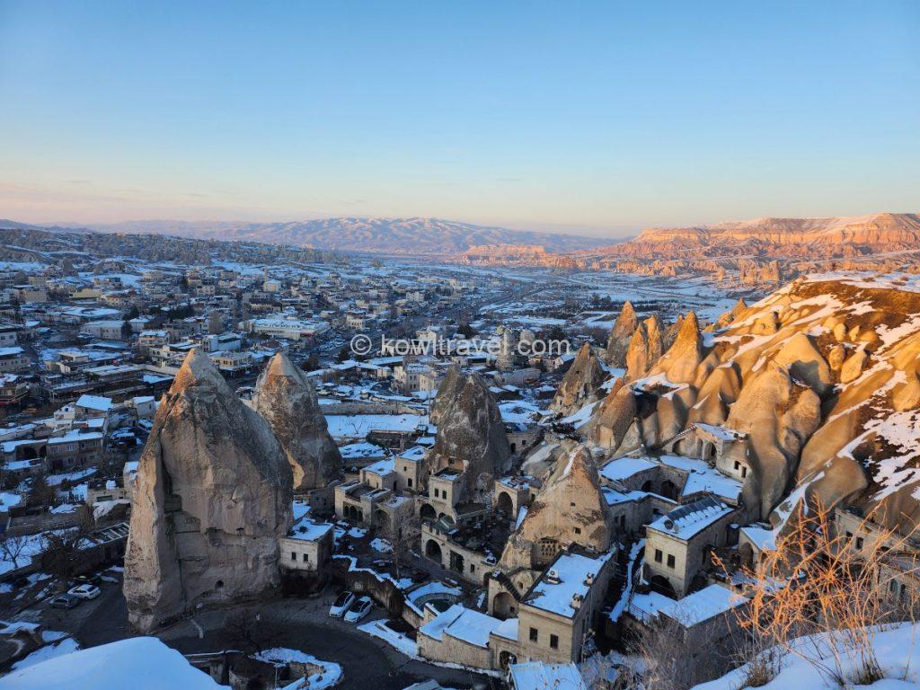
카파도키아 여행의 선셋 포인트에서 바라본 괴레메 마을과 로즈 밸리(오른쪽 뒤편)
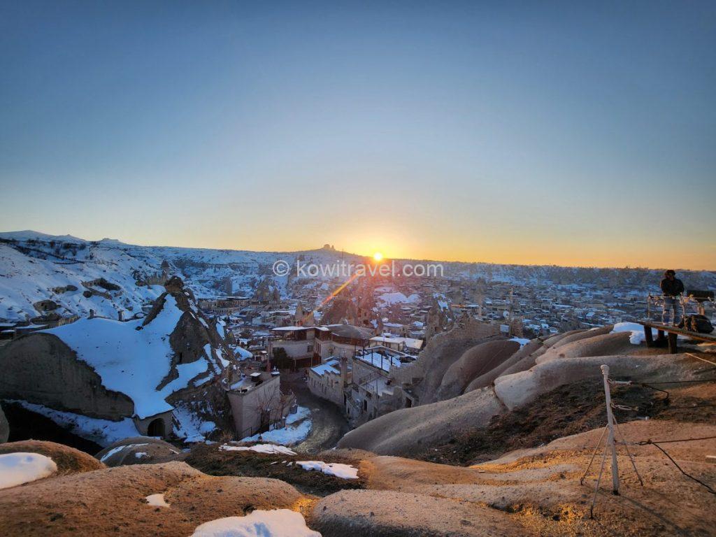
선셋 포인트에서 정면으로 마주하는 감동적인 일몰 순간. 지평선 너머로 해가 걸려 강렬한 태양빛(선플레어)을 뿜어내고 있고, 멀리 눈 덮인 능선 위로 우뚝 솟은 우치사르 성채의 실루엣이 보입니다.
레드 밸리는 철분 함량이 높은 사암과 화산재 퇴적층으로 이루어져 있기 때문에 대낮에는 황토색이나 베이지색으로 보이다가, 일몰 1~2시간 전 45도 각도에서 비스듬하게 들어오는 황금 빛이 비치기 시작하면 순식간에 짙은 분홍색과 화려한 다홍색으로 물들며 비현실적인 행성에 온 듯한 느낌을 줍니다.
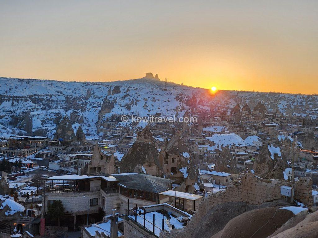
멀리 보이는 우치사르 성채의 실루엣과 함께, 그 아래로 포근하게 자리 잡은 괴레메 마을이 황금빛 노을에 물들어가는 평화롭고 고요한 분위기입니다.

일몰 빛을 정면으로 받아 가장 붉고 아름답게 빛나는 로즈 밸리의 암벽 절벽. 하얀 눈과 붉은 암반층의 대비가 극대화되어 카파도키아 특유의 지형적 신비로움이 돋보입니다.
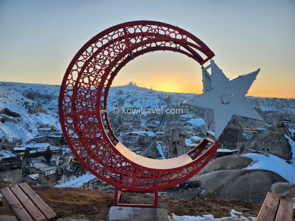
카파도키아 여행의 선셋 포인트 대표적인 포토존인 터키 국기 문양의 붉은색 금속 조형물 뒤의 일몰 모습.
계곡 아래쪽(차부신이나 괴레메 방향)에서 순수하게 도보 트래킹으로 걸어 올라올 경우 입장료는 무료이지만, 위쪽의 선셋 전망대 매표소(차량 진입로)를 통해 들어갈 경우에는 주차비 겸 입장료로 부과되니 참고하시기 바랍니다.
- Tip : 일몰 예정 시간 최소 1시간~1시간 30분 전에는 도착하는 것을 추천 드리는데, 해가 완전히 지평선 너머로 넘어가는 순간보다, 넘어가기 직전 40분 동안 암석에 사선으로 비치는 황금빛 ‘골든 아워’가 훨씬 아름답기 때문입니다. 아울러,고지대 분지 지형 특성상 카파도키아는 해가 지는 순간 기온이 급격하게 뚝 떨어지며 매서운 바람이 불기 때문에, 만약 겨울철에 방문한다면 패딩과 목도리, 핫팩을 준비하시는게 좋으며,바닥이 미끄러우니 운동화나 등산화를 신어야 안전합니다.
4. 우르굽 (Ürgüp)에서의 2박
차부신에서의 알찬 3박을 마치고, 저희는 현지인들의 생활감이 묻어나는 우르굽으로 숙소를 옮겨 2박을 더 즐겼습니다. 카파도키아의 거칠고 광활한 대자연을 온몸으로 느끼는 괴레메와 달리. 우르굽은 카파도키아 여행의 중심지인품격 있고 우아한 매력을 지닌 역사 도시이자 쉼표 같은 도시입니다.

테메니 테페시 전망대에 올라 내려다본 우르굽 마을의 밤 풍경
카파도키아에서 가장 먼저 도시 형태로 번성한 곳 중 하나인 우르굽은, 초기 기독교인들이 로마의 박해를 피해 바위를 파내어 성당과 은신처를 만든 기독교 역사의 성지이자, 성인 ‘요한 (St. John the Russian)’이 서거한 종교적으로도 매우 의미 깊은 도시입니다.
1923년 그리스-터키 인구 교환 전까지 수많은 그리스인과 터키인들이 평화롭게 공존했던 곳이기도 해서, 시내 중심과 외곽을 걷다 보면 전형적인 오스만 양식뿐만 아니라 아름답고 정교한 그리스풍 석조 건축물을 쉽게 만날 수 있어 매우 이국적인 분위기를 풍깁니다.
아울러, 완만한 경사의 언덕과 탁 트인 평지가 조화를 이루는 지형이고, 도로 정비가 잘 되어 있어 렌터카로 운전하거나 시내를 도보로 산책하기에 피로감이 괴레미보다 훨씬 적으며, 현지 주민들의 실제 삶이 녹아 있는 활기찬 로컬 도시입니다..
- 우르굽 추천 명소
1) 판잘르크 계곡 (Pancarlık Valley)
많은 여행객이 카파도키아의 계곡이라고 하면 괴레메 근처의 레드 밸리나 피죤 밸리를 주로 떠올리지만, 우르굽 숙소에 묵으신다면 남쪽으로 차로 5분 거리인 ‘판잘르크 계곡‘을 둘러 보시기를 추천 드립니다..
판잘르크 계곡은 파샤바 등과 같은 다른 유명 관광지에 비해 원뿔 모양의 뾰족뾰족한 바위들이 한곳에 다닥다닥 군락을 이루고 있는 것으로 유명하며, 뒤편으로 수평 형태의 거대한 퇴적 단층 절벽이 병풍처럼 서 있는 구조를 띱니다
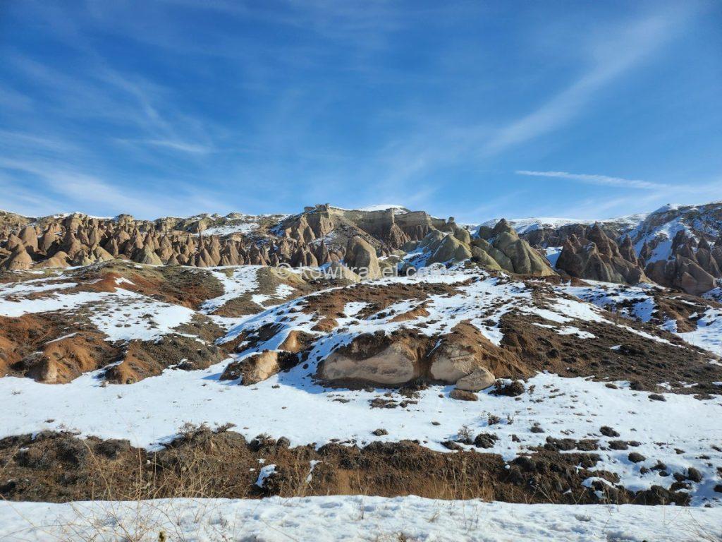
판잘르크 계곡의 독특한 지층과 대지.


판잘르크 계곡 특유의 완만하고 둥글스름한 원뿔 모양 암석들이 언덕을 따라 촘촘하게 군락을 이루고 있는 모습
단체 패키지 투어 발길이 잘 닿지 않는 숨은 로컬 명소라, 저희가 방문했을 때는 관광객이 적어 아무도 밟지 않은 순백의 눈밭과 거대한 단층 절벽이 주는 고요한 대자연을 조용히 감상할 수 있었습니다. 특히 이곳은 주차 구역 반대편 내리막으로 시원하게 뚫린 공터 주차장을 마주 보고 있는 완만한 언덕길 도로와 바로 연결되어 있어, 계곡을 둘러보고 우르굽 시내로 돌아와 로컬 맛집 탐방을 이어가기에도 동선이 완벽합니다.
2) 테메니 테페시(Temenni Tepesi) 언덕 야경
‘소원의 언덕’이라 불리우는 테메니 테페시는 우르굽 시내 한복판에 솟아 있는 거대한 바위 언덕이며, 해발 고도는 약 1,140m이고, 주변 시내 평지로부터는 약 80m 높이로 우뚝 솟아 있어 우르굽 시내 어디서나 쉽게 볼 수 있는 랜드마크입니다.
해가 진 직후의 푸르스름한 하늘(블루아워) 아래, 온통 하얀 눈으로 덮인 마을 집들과 호텔들이 하나둘씩 따뜻한 조명을 켜기 시작하는 동화 같은 순간입니다.
‘테메니(Temenni)’는 옛 수메르어와 터키어에서 ‘소원’, ‘기도’, ‘신성한 장소’ 등을 뜻한다고 하며, 옛날부터 이 언덕 꼭대기에 있는 무덤에 천 조각을 묶으며 소원을 빌던 전통이 이어져 내려와 ‘테메니 테페시(소원의 언덕)’라는 이름이 붙었다고 합니다.


테메니 테페시 정상의 탁 트인 전망대에서 바라본 우르굽 야경
전망대로 올라가기 위해서는 바위를 뚫어 만든 약 80~100m 길이의 독특한 터널을 통과하게 됩니다.
언덕 정상에는 룸 셀주크 제국의 술탄인 이즈 앗 딘 킬리치 아르슬란 4세를 기리기 위해 1288년에 지어진 기념비적인 무덤(쿰베트)이 있으며, 정상에서는 우르굽 시내 전경은 물론 카파도키아 특유의 기암괴석(요정의 굴뚝)과 밸리가 한눈에 들어오는 일몰 명소로 유명하답니다.
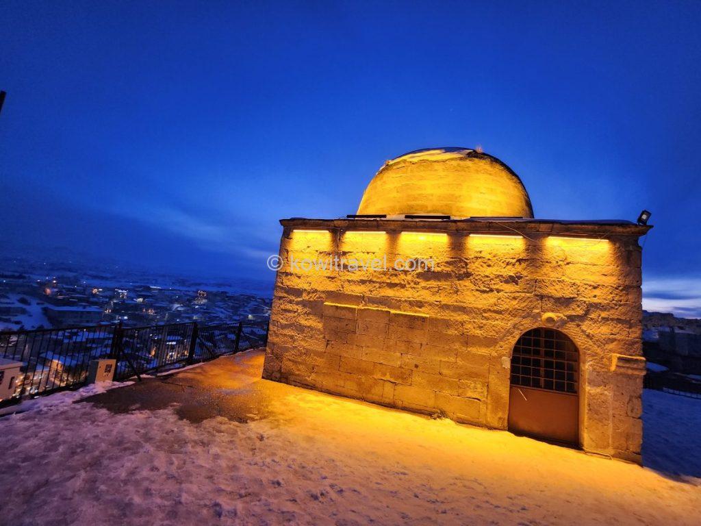
룸 셀주크 제국의 술탄이었던 키치아슬란 4세(Kılıçarslan IV)의 성묘(Tombs)로 알려진 역사적인 장소
정상에 서면, 괴레메의 요정 마을 같은 분위기와는 또 다른, 아늑하고 따뜻한 불빛이 가득한 우르굽 시내의 파노라마 야경이 발 아래로 펼쳐집니다.
얼어붙은 눈길 언덕을 걸어 올라간 보람이 완벽했던, 카파도키아 여행의 완벽한 피날레였습니다.
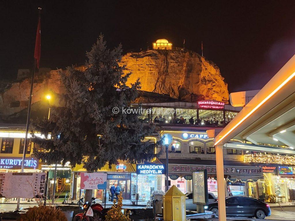
우르굽 시내 중심가에서 올려다본 테메니 테페시 야경.
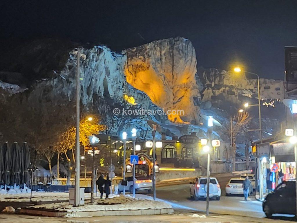
우르굽 시내의 독특한 암벽 거리 야경. 바위의 움푹 파인 부분에 은은한 노란색 조명이 비추어 독특하면서도 아늑한 느낌을 줍니다.
5. 조마조마했던 기다림, 그리고 벌룬 투어 취소
사실 카파도키아에서 오래 묵었던 이유중의 하나는 벌룬을 타기 위함도 있었습니다.
카파도키아 도착 다음날 고객들로부터 평점이 좋은 한 벌룬 투어 대행사를 찾아가 자세한 내용을 안내받고 예약을 했고, 조마조마한 마음으로 스마트폰으로 카파도키아 열기구 실시간 비교·조회 플랫폼인 BalloonScanner 공식 홈페이지를 매일 수시로 확인했습니다. 그러나 야속하게도 벌룬은 뜨지 않았고, 매일매일이 초조함과 기다림의 연속이었습니다.
거의 포기할 무렵이었던 여행 4일 차 저녁, 마침내 예약해 둔 대행사로부터 “내일 아침에는 드디어 벌룬이 뜰 것 같다”는 기쁜 안내 연락을 받았습니다! 설레는 마음으로 일찍 잠자리에 들었고, 다음 날 새벽 4시에 우르굽 숙소 앞으로 저희를 픽업하러 온 차량에 올라탔습니다.
차량은 저희 외에도 다른 여행팀 4팀 정도를 숙소마다 일일이 돌며 픽업한 뒤, 새벽 6시 전후로 괴레메 시내에 있는 벌룬 사무실 앞에 도착했습니다. 차 안에서 대기하라는 안내를 받고 여행사에서 나눠준 간단한 간식을 먹으며 기다리기를 30~40분 정도 이어갔습니다.
조마조마한 마음으로 스마트폰의 실시간 벌룬 확인 앱을 계속 새로 고침하면서 지켜 보았습니다.. 그런데 비행 가능을 뜻하던 초록색 불이 어느 순간 야속하게도 비행 불가를 의미하는 빨간색으로 툭 바뀌어 버렸습니다.
그 순간, ‘아, 여기까지 새벽 바람을 뚫고 왔는데 오늘도 안 되는구나’ 하는 직감이 스쳤고, 이내 가이드가 다가와 바람 때문에 최종 취소되었다는 청천벽력 같은 소식을 전했습니다. 그 오랜 기다림의 시간들이었기에 그 순간 얼마나 허탈했던지..
열기구 취소를 결정하는 가장 치명적이고 결정적인 요인은 역시 ‘바람의 세기’라고 합니다.
열기구(벌룬)는 동력이 없어 위아래로만 고도를 조절할 뿐 오직 바람에만 몸을 맡겨야 하기 때문입니다. 특히 시속 11km 이하의 잔잔한 바람에서만 안전한 비행이 허가되는데, 지상은 고요할지라도 수백 미터 상공의 풍속이 기준을 넘으면 대기 중이던 모든 기구에 일제히 레드 플래그가 떨어집니다.
무엇보다 풍선 자체를 똑바로 세우기 힘든 데다, 자칫 시속 수십 킬로미터로 땅이나 바위에 부딪히는 착륙 사고로 이어질 수 있어 안전이 최우선이기에 블가피한 취소가 납득이 가면서도 아쉬운 마음은 감출 수 없었습니다.
무려 5일 동안 매일 웹사이트와 앱을 체크하며 실낱 같은 희망을 바랬지만, 마냥 벌룬 때문에 카파도키아 일정을 더 연장할 수는 없었기에 최종적으로 벌룬 투어를 포기를 할 수 밖에 없었습니다.
비록 벌룬이 취소되어 허탈했지만, 그것 또한 카파도키아 여행의 강렬한 추억이 되었습니다.
참고로, 아래에날짜별 잔여 슬롯뿐만 아니라 터키 민간항공국(SHGM)의 당일 승인 상태를 새벽 4시부터 실시간으로 알려주는 웹사이트와 모바일 앱을 알려 드리니 참고하시면 도움이 될 것입니다.
6. 여행을 마무리하며
지중해 연안의 안탈리아에서 출발해 눈 덮인 터키 내륙을 관통하고, 데린쿠유에서 차 키를 잃어버려 망연자실했다가 기적 같은 친절로 구사일생했던 에피소드, 그리고 새벽 4시의 긴장감 속에서 마주한 벌룬 취소의 아쉬움까지 모두 카파도키아 여행에서 경험한 소중한 추억으로 간직될 것입니다.
이번 카파도키아 여행 5박 6일은 대자연의 경이로움뿐만 아니라 인간의 따뜻한 순수함, 그리고 렌터카 여행 특유의 다이내믹함을 온몸으로 체험케 해 준 잊지 못할 경험으로 기억될 것 같습니다.
👉 외계행성 같았던 카파도키아 여행 YouTube 영상으로도 만나 보세요!
7. 다음 행선지 ‘에스키셰히르(Eskişehir)’!
원래 저희의 계획은 카파도키아 일정을 모두 마치고 북쪽에 위치한 유서 깊은 마을 샤프란볼루(Safranbolu)나, 눈꽃으로 유명한 볼루(Bolu)로 이동하는 것이었습니다. 하지만 기후 변화로 인해 북쪽 지역에 계속해서 대규모 폭설이 쏟아진다는 예보가 들려왔고, 렌터카를 직접 운전해서 가야 하는 저희로서는 안전상 폭설이 내리는 산길을 고집하는 건 무리라는 생각에 결국 저희는 안전을 위해 행선지를 급하게 ‘에스키셰히르(Eskişehir)’로 변경했습니다.
어차피 볼루 다음이 터키 일주의 최종 종착지인 이스탄불(Istanbul)이기 때문에, 볼루를 거치든 에스키셰히르를 거치든 전체적인 동선에는 큰 차이가 없었기 때문이었고, 오히려 에스키셰히르에서 이스탄불로 올라가는 국도가 거리도 더 짧고 도로 상태도 훨씬 좋아서 저희 같은 렌터카 여행자에게는 훨씬 안전하고 상황에 따른 나름대로의 불가피하고 현명한 변경이었습니다.
[ 튀르키예 1달 자동차 일주 5편 안탈리아 여행 2박3일 보러 가기 ]
“본 포스팅은 제휴 마케팅의 일환으로, 링크를 통해 예약이 이루어질 경우 소정의 수수료를 지급받을 수 있습니다”
[Turkey 1-Month Road Trip] #6. A 6-Day/5-Night Complete Guide to Cappadocia like an Alien Planet (Winter Car Rental Route, Accommodation, Must-Visit Places)
#6. Encountering an Alien Planet at the Edge of the Earth, Cappadocia 6-Day Complete Summary
Hello. Welcome back to the 6th story of our 1-month Turkey car rental road trip series.
Today, leaving behind the warm and gentle Mediterranean resort city of Antalya, I would like to introduce our spectacular 6-day/5-night journey in Cappadocia—a wondrous world where an unrealistic nature that feels like an alien planet coexists with strong human vitality.
For those preparing for a winter Turkey road trip, I will generously share details on snow removal and road conditions, must-visit attractions, hidden local restaurants, and unforgettable episodes encountered during the trip.
1. Departure from Antalya, Journey via the Islamic Holy City Konya
1) Winter National Highway Drive and Road Snow Removal Conditions
As we left Antalya and drove deeper into the northeastern inland, the landscape outside the window dramatically transformed into a white winter wonderland.
To be honest, since it was a winter car rental trip, I was extremely worried about driving on icy roads. Fortunately, the main national highways in Turkey were well-plowed, allowing us to drive with peace of mind. The drive cutting through the wide-open, snow-covered landscape felt like a special privilege that only car rental travelers could enjoy.
A national highway leading from Antalya to Konya. The reddish hue of the mountain face on the left is due to the region’s limestone geology—common along Turkey’s southern Mediterranean coast and the Taurus Mountains. As calcium carbonate in the limestone dissolves and washes away with the rain, residual impurities like iron and aluminum accumulate, forming the red clay seen in the photo. This soil is known as terra rossa (Italian for “red earth”).
**Travel Destination Spoiler / Useful Knowledge**
Antalya and the southern Mediterranean coast of Turkey, as well as the Toros Mountains area, feature well-developed limestone terrains. Limestone composed of calcium carbonate dissolves and washes away in rainwater (karst process), and the remaining insoluble impurities such as iron and aluminum accumulate to form red clay. This is called Terra Rossa (meaning ‘red land’ in Italian).
The grand journey from Antalya to Cappadocia is as follows:
* Total Travel Distance: Approx. 500–515 km
* Travel Time: Approx. 6 hours 30 minutes – 7 hours (Winter standard)
* Recommended Stopover: Konya – Approx. 3 hours 30 minutes from the start of the drive
Therefore, to avoid overexerting ourselves, we decided to take a short break in Konya, our intermediate stopover, before moving on.
2) Intermediary Stopover: Rest at Mevlana Square in Konya
The place we chose as the mid-point of our long journey was Konya, known as the most religious and conservative city in Turkey.
Konya, a flatland where the horizon extends endlessly and the largest wheat producer in Turkey, is said to have been the capital of the Rum Seljuk Empire, which flourished from the 11th to the 13th centuries. Brilliant medieval Islamic architectural heritage built during this period remains throughout the city.
Unlike resort destinations like Istanbul or Antalya, it is known as the most conservative and pious city in Turkey. Furthermore, Konya is where the master poet and thinker Mevlana Rumi lived and was buried, and it is the birthplace of mystical Sufism and the ‘Whirling Dervishes (Sema)’. Every year, countless pilgrims from all over the world visit to seek this message of peace and love.
Mevlana Square, where we stopped after parking the car for a while, exuded a heavy solemnity in the winter chill. The majestic Selimiye Mosque and the turquoise tiled dome—the symbol of the Mevlana Museum, a sanctuary of Islamic mystical Sufism—contrasted beautifully against the crisp blue winter sky, making it feel incredibly exotic.
The Selimiye Mosque (Selimiye Camii), standing majestically right next to the Mevlana Museum, along with the fountain in the center of the plaza.
The exterior of the Mevlana Museum, home to the tomb of Mevlana Rumi—famous for the Sufi dance (Sema dance). The distinctive turquoise-tiled dome (Green Dome) visible behind the roof serves as the museum’s iconic landmark.
It was a wonderful stopover that felt like walking into the deep history of Turkey while catching our breath.
2. Arrival in Cappadocia
After leaving Konya, we drove non-stop for about 220 km along a smooth 4-lane national highway. By the time we approached Nevşehir after nearly 3 hours of driving, heavy snow was falling. It seemed a lot of snow had fallen previously as well, given the substantial piles cleared to the roadside.
- Travel Tip : If you drive for about 1 hour and 40 minutes after leaving Konya, Aksaray is located at the mid-point, so you may refuel or take a light rest there before continuing.
A view of a road captured against the backdrop of Cappadocia’s vast, snow-covered mountains.
Passing through Nevşehir amidst the heavy snowfall, we drove past Uçhisar Castle and through Göreme—the true central town for travelers packed with hotels, restaurants, and bus terminals—before safely arriving at Çavuşin, where our accommodation was located. Çavuşin is a very close neighboring village located about 4–5 km north of the busy Göreme town, just a 5-minute drive away.
(Insert Google Map link: Route from Konya -> Nevşehir -> Göreme -> Çavuşin)
Millions of years ago, Cappadocia was a volcanic region with large-scale eruptions. Volcanic dust—the aftermath of explosions around lava rocks formed by magma eruptions—settled and hardened into tuff. Because tuff has a weaker hardness compared to other igneous rocks, it eroded easily over time, creating the unique ‘fairy chimneys’ (mushroom rocks) characteristic of the Cappadocia region.
Since these rocks possess the unique property of being easily carved out with simple tools, numerous early Christians hid here to escape persecution by the medieval Roman Empire and invasions by Islamic forces.
It became a sanctuary for Christians, who dug deep into the rocks to build complex underground cities capable of housing tens of thousands of people, such as Derinkuyu and Kaymaklı. Furthermore, they carved out cave churches decorated with sophisticated frescoes to preserve their faith.
Today, in recognition of its historical and natural value, Göreme National Park and the Rock Sites of Cappadocia were designated as a UNESCO World Heritage Site in 1985, becoming a world-class tourist attraction boasting one of the most exotic landscapes on Earth.
Also, as the holy land of hot air balloon tours, the sight of hundreds of balloons rising above the unique rock formations every dawn is an essential itinerary item for a Cappadocia trip and is ranked number one on bucket lists worldwide.
1) A 3-Night Stay at ‘Route Cappadocia’, a Cave-like Lodge in Çavuşin Village
After a long drive, we finally arrived safely at our first accommodation in Cappadocia, ‘Route Cappadocia,’ located in the village of Çavuşin.
Situated slightly away from the hustle and bustle of Göreme town, this place offers a relatively serene and peaceful atmosphere, making it perfect for enjoying the cozy winter sentiment. It is a stone house with a cave concept, complete with a charming garden and terrace.
The cave-vibe bedroom, surrounded by rough and stylish stone walls, was incredibly cozy and warm, making us forget the sub-zero temperatures outside. The snowy landscape piled up in the yard was romance itself.
A menu for ordering food and a travel information board about surrounding attractions were available inside, and thanks to the friendly host, we spent a comfortable time feeling right at home throughout our stay.
The interior of the accommodation, enclosed by the rugged yet stylish stone walls characteristic of Cappadocia. Soft lighting and embroidered pillows on the bed create a warm, inviting atmosphere.
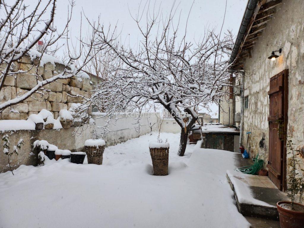
The stone exterior of the accommodation and the romantic winter scene of white snow piled up in the courtyard. It captures the tranquil and magical ambiance of Cappadocia in winter.
It is registered not only on Vrbo but also on major hotel booking sites like Booking.com and Tripadvisor, allowing you to compare prices.
(Accommodation link – Check real-time status and book Route Cappadocia on Booking.com)
(Recommended photos: Route Cappadocia stone-wall bedroom, snow-covered yard, menu board)
2) Night of Day 1: A Walk Through the Fairy Tale-like Göreme Town Night View
After safely unpacking at our lodge, night had already fallen. To officially begin our Cappadocia journey, we drove our rental car to the town with fluttering hearts to enjoy the night view of Göreme.
After parking the car on one side of the town, we carefully walked up the hilly cave hotel alleyways inside the center of Göreme to enjoy the view.
This is a lane lined with hillside cave hotels in the heart of Göreme.
The scene is incredibly romantic, featuring cave accommodations carved directly into massive “Fairy Chimney” rock formations and warm orange lighting reflecting off the snow.
The night scene we suddenly encountered was so unrealistic that it felt mystical and dreamlike. The cave accommodations carved right into the massive ‘Fairy Chimneys’ rocks, the unique rock formations lit by warm orange lights, and the illumination reflecting off the white snow were incredibly romantic.
The exterior of a typical high-end Cappadocian cave hotel, where walls and terraces have been constructed by utilizing the natural rock formations.
It is an impressive sight to see a massive rock spire illuminated from below, glowing majestically against the night sky.
Walking among them made us feel as if we had stepped onto another planet.
Because it was a dark night and the sloped paths were slippery due to the accumulated snow, we couldn’t climb all the way to the Sunset Point. However, looking down at the Göreme town night view from this cave hotel alleyway elevated the romance of our winter Cappadocia trip to its peak from the very first day.
A panoramic view of the town, seen from a high-altitude terrace or the hillside path leading up to Göreme’s Sunset Point.
A view of the charmingly illuminated village of Göreme nestled beneath distant, massive, snow-capped rock mountains; the smooth, frozen snow on the road adds a vivid touch to the experience of a winter trip to Turkey.
3. Core Must-Visit Attractions and Routes in Cappadocia
The reason we allocated a long period of 5 nights and 6 days to our Cappadocia trip was that there were so many attractions, but also primarily to experience the ‘Balloon Tour’—the highlight of Cappadocia. Every morning, we kept an eye on the app that provides real-time balloon flight status, waiting anxiously while exploring various corners of Cappadocia.
1) Exploring the Giant Underground City of Derinkuyu and the Dizzying Episode of the Lost Car Key
On our second day in Cappadocia, we headed to the giant underground city of Derinkuyu.
From Çavuşin to the Derinkuyu Underground City, it takes about 40–45 minutes by car, covering a distance of approximately 38–39 km. The route passes near Göreme and Uçhisar, heading straight south. You will take the national highway, which has wide lanes and is relatively quiet, making it not too difficult to drive.
It usually takes about an hour to fully explore the Derinkuyu Underground City.
The official signature sculpture installed in the plaza of the Derinkuyu Underground City.
As the largest and deepest underground city discovered in the Cappadocia region, Derinkuyu (meaning ‘deep well’ in Turkish) began to be excavated gradually from the BC era. However, around the 7th to 8th centuries during the Byzantine era, it was massively expanded by Christians who fled here to escape Islamic forces and religious persecution by the Roman Empire, serving as their religious refuge.
Reaching a total depth of about 85 meters (equivalent to 18–20 underground floors), this underground city was not a simple cave. It was fully equipped with urban functions, featuring residential areas, kitchens, and food storage, as well as churches, religious schools, wineries, and stables. This complete self-sufficiency allowed residents to stay underground for long periods without going up to the surface.
The official ticket office and the narrow, steep entrance leading into the Derinkuyu Underground City.
It is said to have been a massive residential space capable of accommodating about 20,000 residents along with their livestock and food supplies at its peak. It was truly astonishing and hard to believe that it was built with ancient technology without any specialized modern equipment.
Vast underground living spaces where Christians once hid to escape persecution.
Currently, for safety reasons, it is open to the general public only up to the 8th underground floor (about 30–40 meters deep).
Bending low and heading down the narrow stone steps, you encounter a massive millstone-shaped door that could only be rolled from the inside to block enemy intrusion, along with giant stone pillars.
It was a solemn moment that made us reflect on the desperate and arduous lives, as well as the wisdom, of the ancients who formed a community and protected their faith in this dark, narrow underground world to escape persecution.
(Insert photos: Derinkuyu monument, underground city interior, and millstone door)
Thick rock pillars supporting the underground city and complex, maze-like passageways branching off in various directions.
A wider living area or plaza-like zone; the ceiling is low and rounded, and a narrow staircase connecting the upper and lower levels is visible in the background.
The “stone door,” a key attraction of the Derinkuyu Underground City. It is a massive, millstone-shaped door designed to be rolled shut from the inside to block invading enemies; the central hole reportedly allowed for monitoring the enemy or thrusting spears at them.
Located on one side of the square right in front of the underground city ticket office is the Agios Theodoros Trion Church. It is a historic stone Greek Orthodox church built in the 19th century for the Greek settlers (Greek Orthodox believers) who lived in this region.
It is said to possess excellent acoustic effects and remains of beautiful frescoes depicting angels Gabriel and Michael. However, after the population exchange between Greece and Turkey in 1923, the church was left vacant and abandoned.
Due to years of neglect and some graffiti damage, the doors are currently locked, so the interior cannot be viewed. It is now used as a course lightly explored from the exterior.
A historic Greek Orthodox church built in the 19th century. Constructed sturdily from stone characteristic of Cappadocia, its magnificent bell tower—dusted with fresh snow—creates a serene, beautiful scene against the winter sky.
After finishing our exploration of every nook and cranny of the complex labyrinth-like underground city, we felt hungry, and it happened to be lunchtime.
We headed to a local restaurant near the parking lot called ‘Akdeniz Kebap Salonu.’ It was a modest local diner with a direct view of a snow-covered mosque minaret. The combination of charcoal-scented Adana kebab, tangy meze (side dishes), and ayran we tasted here was unique and good to eat.
A local restaurant located right near the Derinkuyu Underground City ticket office and parking lot.
Adana Kebab, a signature Turkish grilled meat dish. Seasoned minced meat is skewered and charcoal-grilled, then served atop Turkish pide bread to be eaten wrapped together.
The interior of the restaurant and a prominent nearby mosque. Its massive dome and two tall, pointed minarets create an exotic look, contrasting sharply with the brilliant blue winter sky of Cappadocia.
When we arrived at the parking lot and realized that the rental car key, which my wife thought she had securely placed in her jacket pocket, had completely vanished, we felt utterly helpless, wondering, ‘Could this really be happening?’
Episode: Unforgettable Kindness of Turkish People Encountered at a Dizzying Moment
However, leaving the restaurant after finishing our meal, we had no idea that the biggest crisis of our Cappadocia trip—a dizzying and absurd situation that I still cannot forget—was waiting for us.
While I was explaining the lost key situation to the parking attendant who approached thinking our car was leaving, a middle-aged man who looked like the attendant’s neighborhood friend stepped in. Speaking half-English and half-Turkish, and occasionally using a translator, he said, “Think carefully. Where did you go first after parking the car? The restroom? Which restroom? The mosque restroom?” Despite the strict segregation of men and women in Islamic culture, this Muslim gentleman went inside the women’s restroom with my wife and searched every corner thoroughly.
Meanwhile, I retraced our steps back to the restaurant and checked meticulously, but it was in vain. Left with no choice, we decided to check the last remaining place—the underground city. After explaining the situation to the ticket office and getting their permission, I went back inside.
Searching that narrow, deep underground city with countless fork roads using my phone flashlight, sweating profusely in the dead of winter, I ultimately came back up to the surface empty-handed. Thinking about what would happen next, it was clear this was a major problem.
The day was about to turn dark soon, the winter cold was severe, and it wasn’t a distance from which a replacement key could arrive quickly from Istanbul to Cappadocia. That meant the car would eventually have to be towed, we would have to wait shivering in this cold until the tow truck arrived, how would we return to our lodge, and even with Full Cover insurance, key loss and the subsequent towing fees wouldn’t be covered…
Thinking about all of this, the sky felt completely dark. It was truly hopeless, and my head felt like it was going to explode.
As I stood there in despair, the Muslim man who used the translator rushed over and asked, “Did you find the car key?” Having completely lost my mind, I didn’t even have the mental capacity to answer. But then this man began saying something to the surrounding shopkeepers in their language.
At that moment, an uncle at a souvenir shop across the street waved his hand while saying something—and there, dangling from his finger, was our car key! He said, “It was dropped on the snow, so I picked it up and kept it safe.”
We were so drained that we couldn’t even rejoice immediately, but the image of those street uncles rejoicing even more than us is still vivid in my mind. We were deeply grateful, yet exhausted, and it felt like a dream that was hard to believe. We expressed our desire to reward him, whether in cash or through another means, but the uncle repeatedly waved his hands and declined, saying, “I just did what needed to be done.”
Ultimately, to repay that warm heart, we substituted our gratitude by purchasing a few cute souvenirs from his stall. Even thinking about it now brings a tingling sensation to my chest; it was a dream-like moment where we felt the kind, pure affection and hospitality of the Turkish people with our entire bodies.
2) ‘Three Beauties Rocks’ and the Panoramic Observatory
After brushing off our startled hearts and heading back toward our lodge along the national highway, we discovered an observatory located on a hill at the entrance to Ürgüp village. Since the observatory and parking lot were well-arranged right next to the road, providing great accessibility, we parked the car and stepped out.
It was just past 4 PM, and the winter sunset was beginning. As it turned out, this was the panoramic observatory featuring Cappadocia’s signature ‘Three Beauties Rocks (Üç Güzeller)’.
Three Beauties Rocks (Üç Güzeller / Three Beauties)
In Turkish, it is called ‘Üç Güzeller,’ which translates to ‘Three Beauties’ in English, and it is known to Korean travelers as the ‘Three Sisters Rocks’ (or Family Rocks). Geographically, it is located on a hill at the roadside entrance to Ürgüp village, east of Göreme town.
A winter view of the “Three Beauties”—three mushroom-shaped rock formations standing side-by-side as the most famous symbol of Ürgüp—and the mysterious, sprawling volcanic tuff landscape surrounding them.
It takes about 10–12 minutes (approx. 6.5 km) by car from the center of Göreme. The observatory and parking lot are well-situated right next to the road, offering excellent access. When planning your travel itinerary, placing this stop on the way back to Göreme after visiting Derinkuyu is highly efficient for saving time.
Geologically, the soft white tuff volcanic ash layer at the bottom eroded easily due to wind and rain, while the dark, hard basalt layer at the top withstood the erosion and remained intact, maintaining a unique shape that looks like a ‘mushroom wearing a hat’ or a ‘person wearing a cloak.’
Having undergone differential erosion over a long period, the appearance of the three rocks standing side-by-side is unique and beautiful, making it the most frequent feature on Cappadocia travel souvenirs and postcards.
It is said that three famous legends passed down locally are intertwined with these rocks.
- There is a tragic story of a princess whose father, the King of Ürgüp, could not forgive her for running away and having a child with a shepherd. He sent an army after them, and just before being captured, the princess prayed, “Please turn me into stone instead.” Heaven answered, turning the princess (center), her husband (left), and her child (right) instantly into stone rocks.
- Another folklore involves fairy princesses who fell in love with shepherds of the human world. They fled from the king’s anger and hardened into rocks.
- In the Western world, it is often compared to the image of the ‘Charites’ (The Three Graces), who symbolize beauty and elegance in Greek mythology.
The spectacle of mushroom rocks covered in soft white snow and the massive canyon burning red and golden under the setting sun was truly magnificent. We could even clearly view the giant silhouette of Mount Erciyes piercing through the clouds far across the horizon.
A panoramic view of the massive valley straddling the border between Ürgüp and Göreme, seen from the observation deck and parking area.
If it weren’t for a car rental trip, we would have missed this leisure, a moment for which we felt incredibly grateful.
(Photo: Silhouette of the Erciyes snow mountain across the horizon and volcanic terrains)
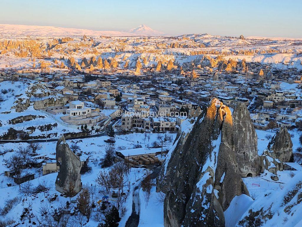
As the afternoon passes 4:00 PM, the low-hanging winter sunlight strikes the snow-covered cliffs, creating a magnificent panorama tinged with hues of red and gold.
3) UNESCO World Heritage Site: Göreme Open Air Museum and the Dark Church
The UNESCO World Heritage Site Göreme Open Air Museum, which we visited on our third day in Cappadocia, was the home of ancient Christians who protected their faith by carving out rooms tier by tier into barren rock mountains.
Signage and the official price list at the ticket booth of the Göreme Open Air Museum.
It is a place where dozens of monasteries and churches, carved into rock mountains by Christians who hid to escape persecution from Rome and Islam from the 4th to the 11th centuries, are gathered.
The arched entrance to St. Basil’s Chapel, located at the museum’s entrance.
A rock formation housing cave churches—a key attraction within the museum. It served as a living space for Cappadocia’s early settlers; the interior of this massive rock, standing as tall as a six- or seven-story building, was carved out to create fully functional areas such as a dining hall, kitchen, bedrooms, and a church.
A panoramic view from the hill at the entrance of the open-air museum. The snow-covered valley in winter creates a serene, mystical atmosphere, as if time itself has stood still.
Stepping inside the rock caves allows you to see frescoes in an excellent state of preservation. In particular, the ‘Last Supper’ fresco inside the ‘Dark Church’ was so vivid and sophisticated that it was hard to believe hundreds of years had passed, sending chills of awe through my entire body.
The interior of the “Dark Church”, which boasts the best-preserved frescoes in all of Cappadocia. The arched wall shown in the photo features a vivid fresco of “The Last Supper,” one of the most famous scenes in Christian history.
A dining area where monks once gathered for meals. The long, integrated stone table and benches, carved directly from the rock, are striking. On the wall at the far end of the table, a fresco depicting the life of Jesus or a biblical scene remains preserved, bearing the marks of time.
4) Fairy Chimneys and the Unique Frame View of Pasabag Valley
Following that, we visited Pasabag Valley, a cluster of mushroom rocks where the most bizarre and beautiful mushroom-shaped formations are concentrated among Cappadocia’s characteristic rock formations, commonly referred to as ‘fairy chimneys.’
Because monks used to perform solitary spiritual practices high atop these rocks in the past, it is also called the ‘Monks Valley.’ The cluster of mushroom rocks (fairy chimneys) that look like they are wearing hats creates a spectacular sight.
Pasabag’s most iconic rock formations—massive pillars that split into two or three “heads” at the top. It is a popular photo spot.
Clusters of numerous “mushroom rocks” (fairy chimneys)—which look as though they are wearing hats—create the illusion of stepping into a fairy-tale village.
A view of Pasabag Valley and the snow-covered plaza. The contrast between the white snow and the blue winter sky evokes the feeling of a scene from a fairy tale.
A close-up of the “hat” (cap) rock at the summit, photographed from beneath the mushroom-shaped rock. The weathered, rough texture of the tuff and the distinct boundary between the rock and the hard basalt layer resting atop it are clearly visible.
In particular, the ‘Frame View,’ capturing the mushroom rocks outside using a window hole inside a cave room as a frame, is the ultimate photo zone for getting the shot of a lifetime.
Entrances and windows of cave dwellings (or hermitages) carved by hand into the base of the massive mushroom-shaped rock. These spaces served as retreats where ancient Christian monks practiced their faith in seclusion from the outside world.
A view looking out through a window inside one of the cave dwellings. The oval-shaped opening acts as a natural frame, creating a picturesque scene of other mushroom-shaped rocks rising solitarily from the snow-covered white plains.
We were also able to see firsthand the traces of the massive rock hole where Saint Simeon lived in seclusion and practiced spiritual devotion for his entire life during the 5th century.
The rock formation housing “St. Simeon’s Hermitage,” the most historically significant site in Pasabag Valley. Shown here are the entrance, secured by an iron gate, and the accompanying steps.
Openings leading into the interior of the rock formation; these served as entry points for the monastery where Christian monks once moved up and down via ladders, praying in isolation.
5) Zelve Open Air Museum with Its Raw Charm
Right next to Pasabag Valley lies the Zelve Open Air Museum, a massive cave village that served not only as a religious refuge for Christians but was also actually inhabited by people until the 1950s.
The official information board at the entrance to the Zelve Open Air Museum. It provides detailed information—in both Turkish and English—about the history and layout of Zelve Valley, along with a map of the walking trails.
Boasting a scale much grander than Göreme and carrying a raw charm, this valley resembles a giant cave apartment complex where actual residents lived until the 1950s. Along three massive valleys, churches, residential areas, flour mills, and pigeon houses are intertwined like a spiderweb across the entire rock mountain, offering a sense of the unrefined, desolate, and grand scale of nature far exceeding that of Göreme.
A panoramic view of the cliff dwellings and walking trails in Zelve Valley. Across the sheer rock faces of the valley—which consists of three massive ravines—numerous openings are densely carved into the stone, marking spaces that once served as homes, churches, and storage areas.
A view of the cliff dwellings from a distance and the three-dimensional layout of the entire Zelve village seen from above the valley
A view of Zelve Valley from inside a cave
The entrance to a cave dwelling carved into a massive rock cliff and an arched passageway inside the cave
6) Uçhisar Castle (Uçhisar Kalesi)
It is said that ‘Uçhisar’ means ‘third fortress’ or ‘border castle’ in Turkish. True to its name, it is a massive natural rock mountain fortress towering at the highest elevation in Cappadocia, about 1,300 meters above sea level.
It is said to have been used as a military fortress from the ancient Roman and Byzantine Empire eras through the Seljuk Turk period. While it looks like a single massive rock mountain from the outside, the interior is carved out densely like a honeycomb, creating numerous rooms, passages, warehouses, and even residential spaces and shelters—a surface version of an ancient underground city.
It is said that when enemies invaded, people hid inside the rock, locked the doors, and defended themselves.
Because it has the highest elevation in all of Cappadocia, climbing to the top of the fortress opens up an unobstructed 360-degree panoramic view extending over the Göreme Valley, Pigeon Valley, and the villages.
It is particularly famous as a sunset and sunrise spot where travelers from all over the world gather to watch the spectacular sight of hundreds of hot air balloons rising at dawn or the landscape turning crimson at sunset.
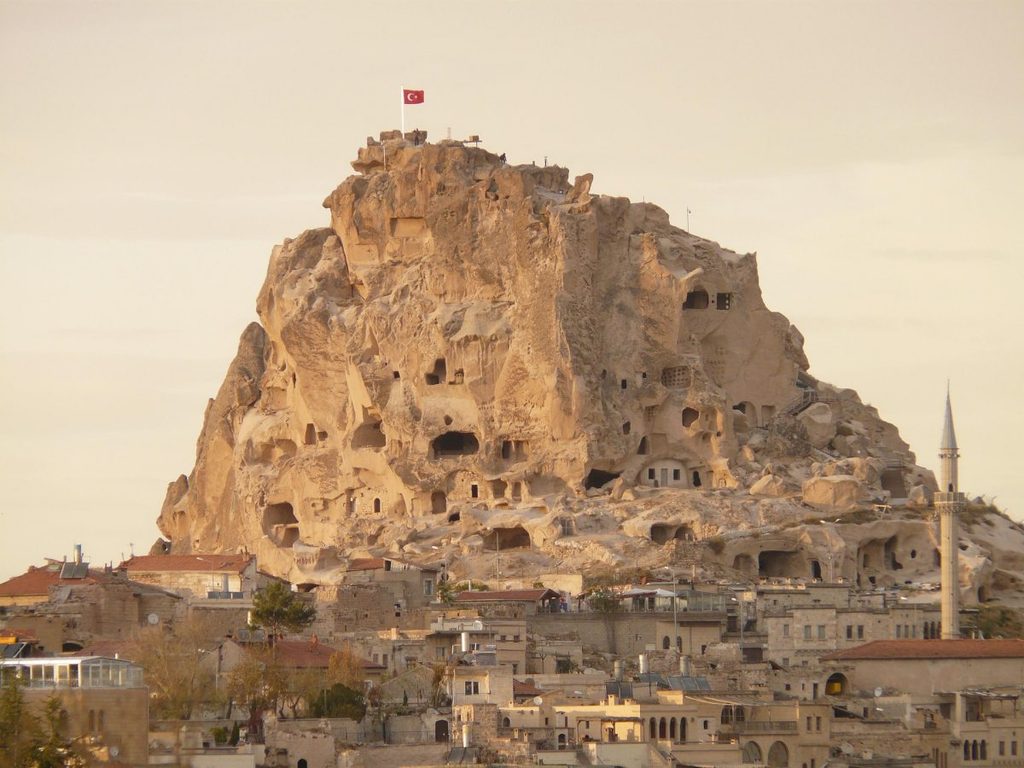
Uçhisar Castle bathed in a soft golden glow at sunset
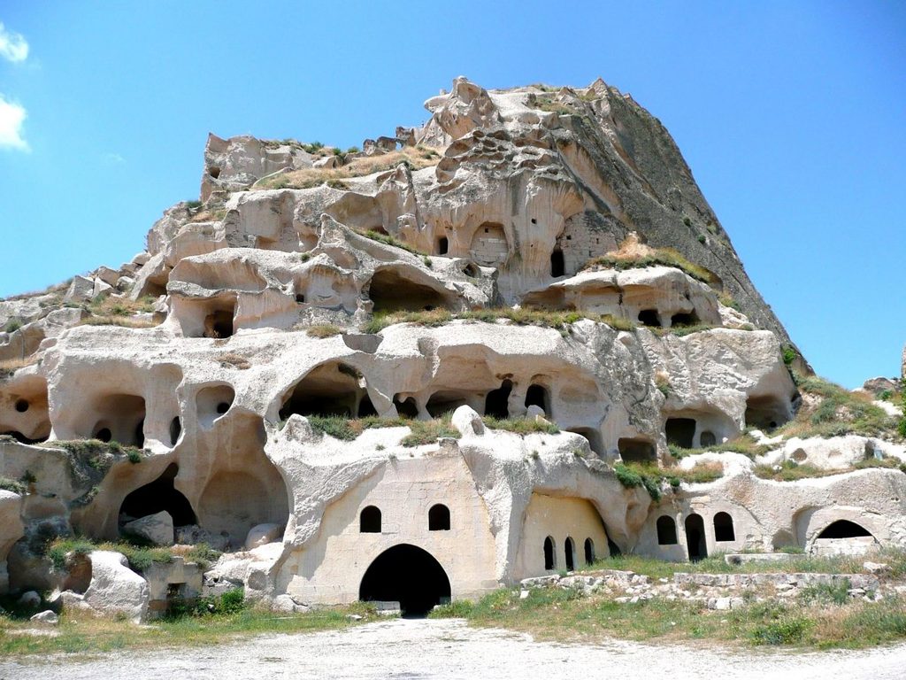
Cave dwellings located at the base of the citadel
7) Sunset Point
Cappadocia’s Sunset Point is an observatory usually located on the ridge where Red Valley and Rose Valley meet. It is the most famous sunset spot in Cappadocia, offering a ‘spectacle of a crimson sunset’ where the white tuff rocks seem to burn, changing from pink to red depending on the angle of the sunlight.
A view of the village of Göreme and Rose Valley (in the background to the right) from a sunset viewpoint in Cappadocia.
A breathtaking sunset moment viewed head-on from the sunset point; the sun hangs just above the horizon, radiating an intense flare, while the silhouette of the Uchisar Castle looms tall over a distant, snow-capped ridge.
Because Red Valley consists of sandstone and volcanic ash sedimentary layers with high iron content, it appears clay-colored or beige during the day.
However, when the golden light hitting at a 45-degree angle begins to shine 1–2 hours before sunset, it instantly stains into a deep pink and brilliant crimson, giving the feeling of being on an unrealistic planet.
The scene captures a peaceful, serene atmosphere as the village of Göreme—nestled cozily beneath the distant silhouette of Uchisar Castle—is bathed in the golden glow of the sunset.
The rocky cliffs of Rose Valley glow a brilliant, deep red as they catch the direct light of the setting sun. The striking contrast between the white snow and the red rock strata highlights the unique geological mystique of Cappadocia.
A sunset view framed behind the red metal sculpture featuring the Turkish flag design—a signature photo spot at the Cappadocia sunset viewpoint.
If you walk up purely via a hiking trek from the lower side (from the direction of Çavuşin or Göreme), the admission is free. However, if you enter through the upper sunset observatory ticket office (vehicle access road), please note that a fee is charged for parking and admission.
- Tip: I recommend arriving at least 1 hour to 1 hour 30 minutes before the scheduled sunset time. Rather than the moment the sun completely drops below the horizon, the ‘Golden Hour’ during the 40 minutes right before it sets—when the golden light shines diagonally onto the rocks—is far more beautiful.
- Furthermore, due to the high-altitude basin terrain characteristics, Cappadocia’s temperature drops rapidly and bitter winds blow the moment the sun sets. Therefore, if you visit during the winter, it is advisable to prepare a padded jacket, a scarf, and hot packs. Since the ground is slippery, you should wear sneakers or hiking shoes for safety.
4. A 2-Night Stay in Ürgüp
After completing a fulfilling 3-night stay in Çavuşin, we moved our accommodation to the Ürgüp area, where the daily life of locals can be felt, to enjoy 2 more nights.
A night view of the town of Ürgüp, seen from the Temenni Tepesi observation point.
Unlike Göreme, where you experience Cappadocia’s rough and vast wilderness with your entire body, Ürgüp is a historical city possessing a dignified and elegant charm—a place that feels like a comma in your Cappadocia journey.
As one of the first places in Cappadocia to flourish in a urban form, Ürgüp is a holy land of Christian history where early Christians carved out rocks to build churches and hiding spots to escape Roman persecution. It is also a highly meaningful city religiously, being the place where Saint John the Russian passed away.
It was also a place where numerous Greeks and Turks coexisted peacefully until the Greek-Turkish population exchange in 1923. Walking through the city center and outskirts, you can easily encounter not only typical Ottoman styles but also beautiful and sophisticated Greek-style stone architectures, giving off a very exotic atmosphere.
Furthermore, it features a terrain where gentle hills and wide-open flatlands harmonize, and the roads are well-maintained, resulting in far less fatigue when driving a rental car or strolling through the town on foot compared to Göreme. It is a lively local city embedded with the actual lives of local residents.
Recommended Places in Ürgüp
1) Pancarlık Valley
When thinking of valleys in Cappadocia, many travelers primarily recall Red Valley or Pigeon Valley near Göreme. However, if you stay at an accommodation in Ürgüp, I highly recommend exploring ‘Pancarlık Valley,’ located just a 5-minute drive south.
Compared to other famous tourist destinations like Pasabag, Pancarlık Valley is renowned for its cone-shaped, pointed rocks clustered closely together in one place. It features a structure where a massive horizontal sedimentary fault cliff stands like a folding screen behind it.
The unique geological formations and landscape of Pancarlık Valley.
A cluster of the valley’s characteristic gentle, rounded, cone-shaped rock formations standing closely together along the hillside.
Since it is a hidden local gem rarely reached by group package tours, there were few tourists when we visited, allowing us to quietly appreciate the pure white snowfield untouched by anyone and the serene nature provided by the giant fault cliff.
In particular, this place connects directly with a gentle uphill road facing an open empty parking lot that slopes down smoothly on the opposite side of the parking area. This makes the itinerary perfect for exploring the valley and returning to Ürgüp town to continue exploring local restaurants.
2) Night View from Temenni Tepesi (Wish Hill)
Temenni Tepesi, referred to as the ‘Wish Hill,’ is a massive rock hill rising right in the middle of Ürgüp town. Towering at about 1,140 meters above sea level and rising about 80 meters from the surrounding flat city ground, it is a landmark that can be easily seen from anywhere in Ürgüp town.
A fairytale-like moment just after sunset—during the “blue hour”—as houses and hotels, blanketed in white snow, begin to light up one by one with warm, inviting glows.
It is said that ‘Temenni’ means ‘wish,’ ‘prayer,’ or ‘sacred place’ in ancient Sumerian and Turkish. A tradition of making wishes while tying pieces of cloth to the tomb atop this hill has been passed down since ancient times, giving it the name ‘Temenni Tepesi (Wish Hill).’ To ascend to the observatory, you pass through a unique tunnel carved through the rock, measuring about 80–100 meters in length.
A night view of Ürgüp seen from the open observation deck at the summit of Temenni Tepesi.
At the summit of the hill sits a monumental tomb (Kümbet) built in 1288 to honor Izzeddin Kilij Arslan IV, a sultan of the Rum Seljuk Empire. The summit is famous as a sunset spot offering a single-view grasp of the Ürgüp town landscape, as well as Cappadocia’s characteristic rock formations (fairy chimneys) and valleys.
A historic site known as the tomb of Kılıçarslan IV, a sultan of the Rum Seljuk Empire.
Standing at the summit, a panoramic night view of Ürgüp town filled with cozy and warm lights unfolds beneath your feet, presenting a vibe different from the fairy-tale town atmosphere of Göreme. Walking up the frozen snowy hill was completely worth the effort—it was a perfect finale to our Cappadocia trip.
A night view of Temenni Tepesi looking up from the center of Ürgüp.
A night view of a unique rock-face street in downtown Ürgüp; soft yellow lights illuminating the recesses in the rock create an atmosphere that is both distinctive and cozy.
5. An Anxious Wait, and the Hot Air Balloon Tour Cancellation
In fact, one of the reasons we stayed in Cappadocia for a long time was to ride the hot air balloon. The day after arriving in Cappadocia, we visited a balloon tour agency that had excellent ratings from customers, received detailed guidance, and made a reservation.
With an anxious heart, we frequently checked the official website of BalloonScanner, a real-time hot air balloon comparison and inquiry platform for Cappadocia, on our smartphones every day. Unkindly, however, the balloons did not fly, and each day was a continuation of anxiety and waiting.
On the evening of our 4th day of travel, when we had almost given up, we finally received a joyful notice from the agency we booked with, saying, “It looks like the balloons will finally fly tomorrow morning!”
With fluttering hearts, we went to bed early, and at 4 AM the next morning, we boarded the vehicle that came to pick us up in front of our Ürgüp accommodation. In addition to us, the vehicle picked up about 4 other travel teams, stopping at each lodging one by one, before arriving in front of the balloon office in Göreme town around 6 AM.
After receiving instructions to wait inside the car, we waited for about 30–40 minutes while eating light snacks provided by the travel agency.
With an anxious heart, we kept refreshing the real-time balloon confirmation app on our smartphones to watch. However, the green light indicating flight availability suddenly flipped to red, which signified a flight ban.
At that moment, a gut feeling flashed through me: ‘Ah, we came all this way cutting through the early morning wind, but it’s not happening today either.’ Soon after, the guide approached and delivered the thunderbolt news that the flight was ultimately canceled due to the wind. Because it came after such a long period of waiting, how hollow that moment felt…
The most critical and decisive factor that determines a hot air balloon cancellation is indeed the ‘wind speed.’
This is because hot air balloons have no propulsion and only adjust their altitude up and down, relying entirely on the wind to move. In particular, safe flights are permitted only in gentle winds of 11 km/h or less. Even if the ground is calm, if the wind speed hundreds of meters above ground exceeds the standard, a red flag is dropped simultaneously on all balloons on standby.
Above all, it is difficult to stand the balloon envelope upright, and it can lead to landing accidents where the balloon crashes into the ground or rocks at tens of kilometers per hour. Therefore, because safety is the top priority, the Civil Aviation Directorate issued a decisive cancellation order right before boarding.
We kept checking the website and app every day for 5 days, hoping for a glimmer of hope, but we couldn’t extend our Cappadocia schedule indefinitely just for the balloon. Ultimately, with hearts full of regret, we had no choice but to give up on the balloon tour. Although we felt hollow because the balloon was canceled, even that became a intense memory of our winter Cappadocia trip.
For your reference, below are the website and mobile app that inform you of the real-time daily approval status from the Turkish Directorate General of Civil Aviation (SHGM) starting from 4 AM, as well as the remaining slots by date, so it will be helpful to take note.
6. Concluding the Journey
Starting from Antalya on the Mediterranean coast, cutting through the snow-covered inland of Turkey, the episode of feeling completely devastated after losing the car key in Derinkuyu only to be saved by a miracle-like kindness, and the regret of facing the balloon cancellation amidst the tension of 4 AM—all of these will be kept as precious memories experienced during our Cappadocia trip.
This 6-day/5-night Cappadocia trip will be remembered as an unforgettable experience that allowed us to experience not only the wonders of nature but also the warm purity of humans and the dynamic nature characteristic of a car rental road trip with our entire bodies.
“Watch the vivid video of our Cappadocia journey on YouTube!”
(Please turn on YouTube CC(Subtitles) and select your language in settings!)
7. To the Next Destination, ‘Eskişehir’!
Originally, our plan after completing all Cappadocia itineraries was to move to Safranbolu, a historic village located to the north, or Bolu, famous for its snow flowers. However, due to climate change, forecasts kept warning that heavy blizzards were continuously pouring over the northern region.
As we had to drive the rental car ourselves, we thought it would be reckless to insist on mountain roads covered in heavy snow for safety reasons. Ultimately, for our safety, we abruptly changed our destination to ‘Eskişehir.’
Since the final destination of our Turkey tour after Bolu was Istanbul anyway, whether we went via Bolu or via Eskişehir didn’t make a big difference in the overall route. Rather, the national highway going up from Eskişehir to Istanbul was shorter in distance and had much better road conditions, making it far safer for rental car travelers like us and a necessary yet wise adjustment given the circumstances.
[ Read Part 5 of our 1-Month Turkey Road Trip : Antalya Trip 3-Day/2-Night ]
“This post includes affiliate marketing links. If you make a accommodation booking through these links, I may earn a small commission at no additional cost to you.”